
Explore
Intelligence
Essential Planning Guide
Warwan Valley Trek — Complete Guide (2026)
Vibe & Scenery
The Experience
Introduction
Few Himalayan treks showcase such dramatic changes in landscape as the journey into Warwan Valley. The expedition begins amid the stark mountains of the Suru Valley before crossing a high pass into one of Kashmir's most isolated and spectacular valleys.
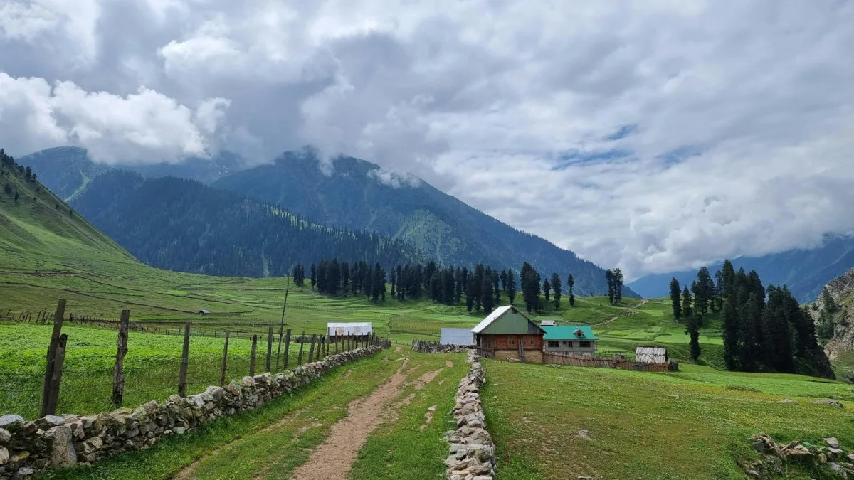
Along the way, trekkers traverse glaciers, broad river valleys, alpine meadows, and remote shepherd camps while remaining far from permanent roads for much of the journey. The transition from Ladakh's cold desert to Kashmir's lush mountain valleys makes this one of the most visually diverse trekking routes in the Indian Himalayas.
Long distances, difficult logistics, and sustained high-altitude travel make Warwan Valley best suited to experienced trekkers seeking a true expedition rather than a conventional trek.
Quick Facts
Duration
Max Altitude
Difficulty
Best Time
Trek Distance
Trail Atmosphere
Stargazing
Class 1 Dark Sky
Scent Profile
Silence Level
~10 dB
Vertigo Factor
4 / 10
Iconic Spots
Lomvilad Pass Edge
Sukhnai Village
Suru Valley Arid Peaks
Environment
Nature & Culture
Flora & Fauna
Flora
Fauna
The route was part of the ancient trans-Himalayan trade network, where salt and wool from Tibet were traded for Kashmiri spices.
— Local folklore
Spiritual & Cultural Significance
The transition from the Tibetan-Buddhist influenced Suru valley to the Islamic Kashmiri Warwan valley offers a profound cultural gradient.
Temple Protocols
Technical Details
Challenge & Preparation
Primarily a cardio demand and cumulative fatigue challenge
A capable trekker's route that balances cardio demand and cumulative fatigue.
Personal Readiness
Am I ready?
Planning
Logistics & Trail Intel
Getting There
Route to Base
Fly into Srinagar
Drive 9 hours via Zoji La and Kargil to reach Panikhar in the Suru Valley
Base Village
Panikhar (Start) / Inshan (End)
10,826 ft
Last ATM
Kargil (Day 1).
Nearest Medical Facility
Kargil Hospital (start) / Anantnag Hospital (end).
Mobile Signal
Total blackout from Day 3 to Day 8.
Water Sources
Glacial streams and the Warwan river provide abundant water. Always use purification tablets.
Charging
Total blackout for 7 days.
For Drivers
Road Condition
The drive to Panikhar (via Zoji La) is tough. The return drive from Inshan via Margan Top is a brutal, unpaved bone-rattler.
Kargil (Start) / Anantnag (End)
Trail Culinary & Diet
Don't miss the Kashmiri Kahwa to survive the freezing nights
Buy specialized diet items at Srinagar
The Content & Remote Hub
No DronesStrictly prohibited by the military due to proximity to the Line of Control.Top Vlog Spots
Video Calls
none
Est. 0 Mbps
UPI Reliability
1/10
Permits and Regulations
Inner Line Permits (ILP) are mandatory and checked at military outposts in Panikhar and Inshan. Drone flying is strictly prohibited across the entire route due to its proximity to the Line of Control and sensitive military zones.
Learn more about how we vet operators and ensure transparency on our why MountRoutes page.
Packing List
High-Altitude Clothing
- Heavyweight expedition down jacket (-10°C rating)
- Gore-Tex windproof/waterproof jacket and trousers
- Merino wool thermal base layers (2-3 sets)
- Fleece mid-layer sweaters
- Quick-dry trekking trousers (x3)
Technical Footwear & Gear
- Rigid, high-ankle waterproof trekking boots (broken in)
- Microspikes (essential for traversing the Lomvilad glacier)
- Waterproof gaiters (mandatory for deep snow and river crossings)
- Trekking poles with snow baskets
- Camp shoes (lightweight sneakers or crocs) for river crossings
Expedition Camping & Survival
- 4-season sleeping bag (-10°C comfort)
- Closed-cell foam sleeping mat (R-value 3+)
- Category 4 UV sunglasses (snow blindness risk on the glacier)
- High-altitude first aid kit with Diamox and blister tape
- Military-grade water purification tablets or pump filter
Accessories & Logistics
- 60-70L expedition backpack with heavy-duty rain cover
- Original Government ID and multiple photocopies (For army checkpoints)
- High SPF 50+ sunscreen and zinc lip balm
- Headlamp with spare lithium batteries
- 2x 1L Nalgene water bottles
Deep Dives
Explore Further
Editor's Notes
Explore In Detail
Day by Day Itinerary
9-day route reaching 14,500ft. Covers 76.0km of varied terrain.
→ See full itinerary with altitude profileDifficulty & Fitness
Rated moderate. The trek offers every Himalayan terrain possible: dusty desert tracks, sharp glacial moraines, crevassed ice fields, and lush alpine grass.
→ See difficulty breakdown and fitness guideCost & Pricing
Packages range from 25,000 - 35,000 INR (Srinagar to Srinagar). Inclusions and hidden costs vary by operator tier.
→ See full cost breakdownFrequently Asked Questions
How difficult is the Warwan Valley trek?
It is rated as Difficult. It is a grueling 9-day expedition covering 80km of harsh terrain. You must cross a massive glacier at 14,500 ft, navigate icy river crossings, and endure absolute isolation. It is not for beginners.
Is the Lomvilad Pass dangerous?
The pass crossing involves a long glacier walk. While not highly technical (no ropes required), it is heavily crevassed in sections. You must walk in a single file behind your guide and use microspikes if the ice is hard.
Are there any villages along the route?
You will start in Panikhar (Suru Valley) and will not see a single village or road until Day 7 when you reach the remote wooden village of Sukhnai in the Warwan Valley.
What happens in a medical emergency?
Evacuation is extremely difficult. Once you cross the Lomvilad pass, there is no turning back. You must be carried by mules to the nearest roadhead (either Panikhar or Inshan). Satellite phones (if carried by the operator) are the only way to contact military helicopters.
Will my phone work?
You will have BSNL/Jio network in Kargil/Panikhar on Day 1. After that, expect a total blackout for 7 days until you drive back towards Srinagar on Day 9.
Do I need special permits?
Yes. The trek crosses sensitive border regions between Ladakh and Jammu & Kashmir. Inner Line Permits are required and must be arranged by a registered trekking operator.
How cold does it get?
Even in August, night temperatures at the high camps (Kalapari and Kaintal) can easily drop to -5°C to -10°C, especially on the glacial moraines.
Is water readily available?
Yes, water is abundant from glacial streams and the Warwan river. However, due to grazing livestock in the lower valleys, all water must be strictly purified.
Still deciding?
Compare routes side-by-side to find the perfect match for your fitness, dates, and budget.
Everything you need to know, in one place. Someone else in your group needs to see this.
Planning Warwan Valley Trek?
Get route conditions, operator updates, and season windows before booking.
Don't miss out! Follow us for route updates@mountroutes|LinkedIn
No spam. Only useful trek updates.
Ready to walk this route?
You’ve read the guide, now find the perfect local team to take you there. Compare our verified list of operators.
Compare verified operators