Explore
Intelligence
Essential Planning Guide
Nag Tibba Trek — Complete Guide (2026)
Vibe & Scenery
The Experience
Introduction
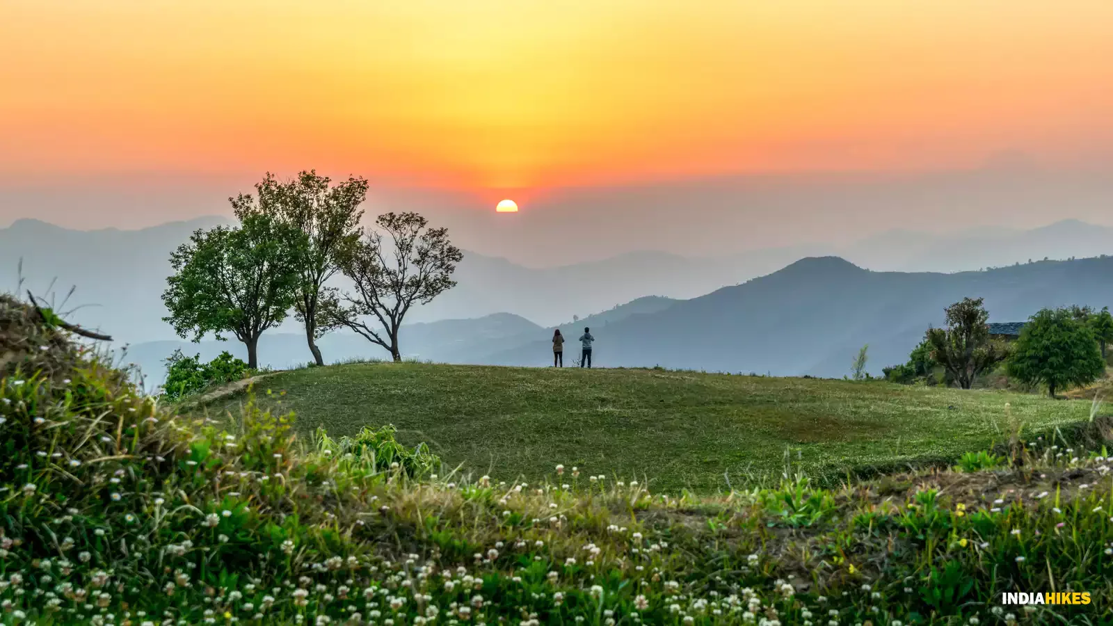
The Nag Tibba Trek climbs to the highest peak in the lower Garhwal Himalayas, offering one of the most rewarding short trekking experiences near Mussoorie and Dehradun. Rising to approximately 9,915 ft, the trail winds through oak and deodar forests before emerging onto an open summit ridge with expansive views of the Greater Himalayan ranges.
Despite its modest altitude, the summit delivers remarkable panoramas of Bandarpoonch, Swargarohini, Kedarnath, Gangotri, and numerous surrounding peaks. The combination of easy accessibility, forest camping, and rewarding summit views has made Nag Tibba one of Uttarakhand's most popular weekend treks.
Suitable for beginners, families, and experienced trekkers looking for a short mountain escape, Nag Tibba provides an excellent introduction to Himalayan trekking throughout much of the year.
Quick Facts
Duration
Max Altitude
Difficulty
Best Time
Trek Distance
Trail Atmosphere
Stargazing
Class 3 Dark Sky
Scent Profile
Silence Level
~45 dB
Vertigo Factor
1 / 10
Iconic Spots
Nag Tibba Summit (9,915 ft)
The Goat Village
Environment
Nature & Culture
Flora & Fauna
Flora
Fauna
Nag Tibba (Serpent's Peak) is believed to be the abode of 'Nag Devta' (Serpent God). Local villagers from the Jaunpur region climb here to offer prayers for the safety of their livestock.
— Local folklore
Spiritual & Cultural Significance
Abode of Nag Devta.
🕐 Shrine Timings: Daylight
Temple Protocols
- •Do not touch the main stone altar
- •Respect local Gaddi protocols
Technical Details
Challenge & Preparation
Primarily a joint & muscle impact challenge
A capable trekker's route dominated by extreme joint & muscle impact.
Personal Readiness
Am I ready?
Planning
Logistics & Trail Intel
Getting There
Route to Base
4-hour drive from Dehradun
Shared jeeps available from Dehradun Rly Station or Mussoorie Library Chowk
Base Village
Pantwari
4,642 ft
Nearest Railhead
Rishikesh
Nearest Airport
Jollygrant Airport
Last ATM
Nainbagh (15km before Pantwari). Highly unreliable.
Nearest Medical Facility
Nainbagh PHC or Mussoorie Civil Hospital.
Mobile Signal
Strong signal at Pantwari and Goat Village (Jio/Airtel). Spotty/Weak at the base camp and summit ridge.
Water Sources
Goat village base has reliable piped water. Nag Tibba base camp depends on stored water carried by mules. Filter required.
Charging
Electricity available at 'Goat Village' homestays. None beyond this point.
For Drivers
Road Condition
Good road from Dehradun via Mussoorie/Yamuna Bridge. Prone to traffic at Mussoorie.
Mussoorie / Dehradun
Trail Culinary & Diet
Don't miss the Mandua Roti (Finger Millet)
Buy specialized diet items at Dehradun / Mussoorie
The Content & Remote Hub
Top Vlog Spots
Video Calls
base-only
Est. 18 Mbps
UPI Reliability
4/10
Base WiFi Available
Permits and Regulations
Nag Tibba falls under the Mussoorie Forest Division. Currently, entry permits are required and can be arranged at the base village (Pantwari). Indian nationals need a valid photo ID (Aadhar/Passport). Foreigners must provide passport/visa copies.
Learn more about how we vet operators and ensure transparency on our why MountRoutes page.
Packing List
Winter Clothing
- Light puffer jacket (Winter only)
- 2 full-sleeve t-shirts
- 1 fleece layer
- Windcheater/Raincoat
- Trekking pants
- Woolen socks (1 pair for night)
Footwear Snow Gear
- Trekking shoes with good grip
- Slippers for camp
Gear Safety
- Trekking pole
- Headlamp or Torch
- Water bottle (2L minimum)
- Sunscreen and Sunglasses
- Personal meds
Deep Dives
Explore Further
Editor's Notes
The fastest way to reach the snow from Delhi. Leave Friday night, back Sunday night.
Highest peak in the Nag Tibba range — offers views that rival treks twice its height.
Explore In Detail
Day by Day Itinerary
2-day route reaching 10,000ft. Covers 16km of varied terrain.
→ See full itinerary with altitude profileDifficulty & Fitness
Rated moderate. A consistent but manageable uphill. The first half from Pantwari is on a rocky stone trail, while the second half enters a semi-dense forest. The final ridge is moderate.
→ See difficulty breakdown and fitness guideCost & Pricing
Packages range from ₹3,500 – ₹7,500. Inclusions and hidden costs vary by operator tier.
→ See full cost breakdownFrequently Asked Questions
Is Nag Tibba suitable for children?
Yes, it is one of the best family-friendly treks. The gradients are gentle, and the total walking time is manageable for kids aged 8 and above.
Can I do Nag Tibba as a day trek?
While possible for very fit individuals from Pantwari, it is best experienced as a 2-day trek to enjoy the sunrise and camping at the base camp.
Why is it called Serpent’s Peak?
Nag Tibba translates to "Serpent Peak". It is named after the Nag Devta (Serpent God) worshipped by the locals for the protection of their cattle.
What is the view from the summit?
The summit offers a 360-degree view of the Garhwal Himalayas, including Swargarohini, Bandarpoonch, Srikanth, and the Gangotri group of peaks.
Is there snow in January?
Yes, Nag Tibba gets excellent snow in winter (Dec-Feb), making it a popular choice for beginner snow treks near Mussoorie.
Where is the last ATM or mobile point?
Mussoorie or Dehradun is the last reliable point for ATMs. Pantwari village has sporadic mobile signals.
Is water available on the trail?
There is only one reliable water source near the base camp. It is recommended to carry at least 2 liters of water from the start.
Which is the better route: Pantwari or Devalsari?
The Pantwari route is shorter and more popular. The Devalsari route is longer, passes through thick oak forests, and is preferred by bird-watchers.
Route Intelligence
Routes With Similar Character
Routes that share the character of Nag Tibba Trek.
Kheerganga Trek
Both offer high reward on a compressed 2-4 day timeline. They share multiple characteristics.
Triund Trek
Both offer high reward on a compressed 2-4 day timeline. They share multiple characteristics.
Hampta Pass Trek
Both serve as excellent introductions to multi-day Himalayan trekking.
Still deciding?
Compare routes side-by-side to find the perfect match for your fitness, dates, and budget.
Everything you need to know, in one place. Someone else in your group needs to see this.
Planning Nag Tibba Trek?
Get route conditions, operator updates, and season windows before booking.
Don't miss out! Follow us for route updates@mountroutes|LinkedIn
No spam. Only useful trek updates.
Ready to walk this route?
You’ve read the guide, now find the perfect local team to take you there. Compare our verified list of operators.
Compare verified operators