
Explore
Intelligence
Essential Planning Guide
Miyar Valley Trek — Complete Guide (2026)
Vibe & Scenery
The Experience
Introduction
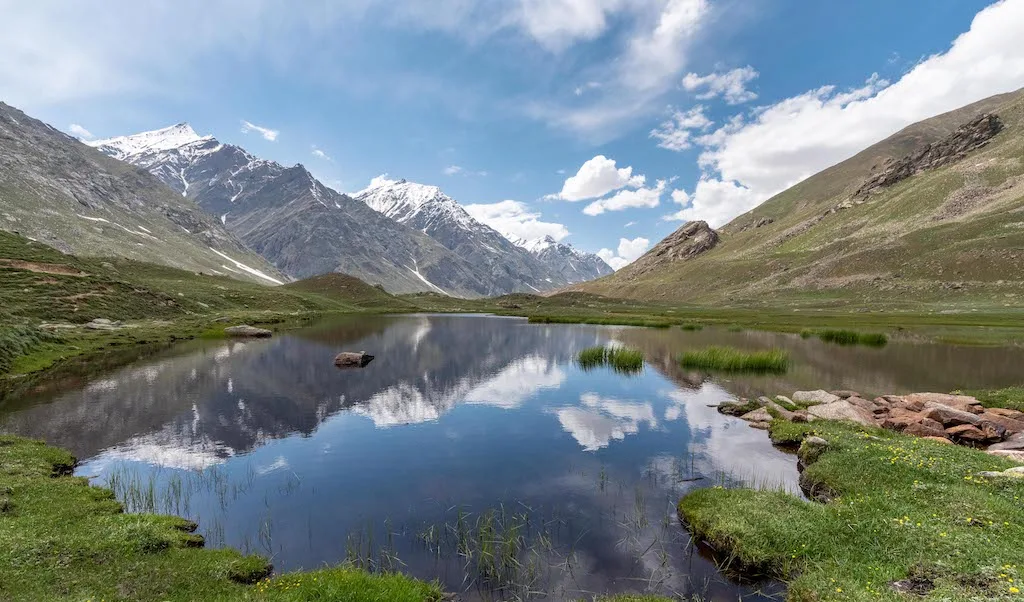
Miyar Valley is widely regarded as one of the finest trekking destinations in the Indian Himalayas. Stretching deep into the Lahaul region, the valley is famous for its immense granite cliffs, expansive alpine meadows, and one of the longest glacier systems in Himachal Pradesh.
Beginning in the remote villages of Miyar Valley, the trek follows the Miyar Nala upstream through traditional Buddhist settlements, colourful summer pastures, and increasingly wild mountain terrain. The landscape gradually becomes more dramatic as towering rock walls, hanging glaciers, and the immense Miyar Glacier dominate the valley.
Unlike many Himalayan expeditions that focus on crossing a high pass, Miyar Valley is about immersion within a spectacular glacial landscape. Its combination of isolation, botanical diversity, and extraordinary mountain scenery has earned it comparisons with California's Yosemite Valley while retaining an unmistakably Himalayan character.
Quick Facts
Duration
Max Altitude
Difficulty
Best Time
Trek Distance
Trail Atmosphere
Stargazing
Class 1 Dark Sky
Scent Profile
Silence Level
~15 dB
Vertigo Factor
2 / 10
Iconic Spots
Yolling & Zardong Meadows
Miyar Glacier Snout
Emerald Lakes
Environment
Nature & Culture
Flora & Fauna
Flora
Fauna
The local Lahauli communities practice a unique blend of Hinduism and Tibetan Buddhism. Tiny gompas (monasteries) dot the landscape, and Gaddi shepherds consider the valley a sacred grazing sanctuary.
— Local folklore
Spiritual & Cultural Significance
The valley blends Hinduism and Tibetan Buddhism. Small gompas and prayer flags mark the route, blessing travelers heading towards the high passes.
🕐 Shrine Timings: Open all day
Temple Protocols
- •Always walk clockwise around Chortens (stupas)
- •Do not touch religious artifacts without permission
Festivals & Dates
Technical Details
Challenge & Preparation
Primarily a cardio demand and joint & muscle impact challenge
A capable trekker's route that balances cardio demand and joint & muscle impact.
Personal Readiness
Am I ready?
Planning
Logistics & Trail Intel
Getting There
Route to Base
Drive from Manali through the Atal Tunnel, cross Keylong/Tandi to Udaipur, and continue off-road to Shukto
Base Village
Shukto / Khanjar
11,100 ft
Last ATM
Udaipur (Unreliable) / Keylong. Best to withdraw in Manali.
Nearest Medical Facility
Community Health Centre, Udaipur / Regional Hospital, Kullu
Mobile Signal
Drops completely after Udaipur/Shukto.
Water Sources
Abundant glacial streams. Ensure water is collected in the morning before glacial silt levels rise in the afternoon.
Charging
Zero charging points after Khanjar. A large solar panel or high-capacity power bank is mandatory.
For Drivers
Road Condition
Tarmac is excellent up to Tandi via Atal Tunnel. From Udaipur to Shukto, the road is unpaved, extremely dusty, and strictly 4x4 or high-clearance vehicle territory.
Tandi (Famous last petrol pump on the Manali-Leh highway).
Trail Culinary & Diet
Don't miss the Thukpa and Momos in Udaipur before the trek begins.
Buy specialized diet items at Manali
The Content & Remote Hub
Top Vlog Spots
Video Calls
none
UPI Reliability
1/10
Permits and Regulations
There are no restrictive inner-line permits required for Indian nationals trekking up to the Miyar Glacier snout. However, standard forest camping permits and registration at the Udaipur Police Station and Shukto check-post are mandatory. Foreign nationals must carry valid passports and may require area registration in Keylong/Udaipur. Strict 'Leave No Trace' policies apply throughout the pristine valley.
Learn more about how we vet operators and ensure transparency on our why MountRoutes page.
Packing List
Layering & Clothing
- Heavy down jacket rated to -5°C
- Windproof/waterproof hardshell jacket
- 3 thermal base layers (synthetic or merino wool)
- 2 fleece mid-layers
- Quick-dry trekking pants (2 pairs)
- Woolen trekking socks (4 pairs)
- Waterproof gloves and woolen inner liners
- Fleece beanie and sun-hat
Footwear & Terrain Gear
- Waterproof trekking boots with deep lugs (Vibram sole)
- Camp sandals or lightweight shoes
- Neoprene socks for glacial river crossings
- Water-resistant high-ankle gaiters
- Trekking poles with mud baskets
Safety & Survival
- Headlamp with 2 spare sets of batteries
- Sleeping bag rated to -10°C
- UV400 Polarized Sunglasses (wrap-around style)
- High SPF Sunscreen (50+) and Lip Balm
- Personal First-Aid Kit with Diamox
- Water purification tablets or Lifestraw
Deep Dives
Explore Further
Editor's Notes
Explore In Detail
Day by Day Itinerary
7-day route reaching 14,000ft. Covers 70.0km of varied terrain.
→ See full itinerary with altitude profileDifficulty & Fitness
Rated moderate. The trail is predominantly characterized by wide, flat valley floors, massive alpine meadows, and intermittent boulder fields. The final stretch to the glacier snout involves unstable lateral and terminal moraine.
→ See difficulty breakdown and fitness guideCost & Pricing
Packages range from ₹16,000 – ₹24,000. Inclusions and hidden costs vary by operator tier.
→ See full cost breakdownFrequently Asked Questions
What is the difficulty level of the Miyar Valley trek?
It is rated as Moderate. While the altitude gain is gradual compared to steep pass crossings, the trek involves long daily walking distances (up to 15-20 km on return days) and freezing, knee-deep river crossings.
When is the best time to do this trek?
The prime window is from late July to mid-September. This is when the valley is in full bloom with wildflowers. Unlike other Himalayan regions, Lahaul is in a rain-shadow zone, making it accessible during the monsoon.
Is it safe to drink water from the streams?
While the high-altitude glacial streams are generally clean, it is highly recommended to use purification tablets or portable filters to avoid gastrointestinal issues from glacial silt.
Are there any mobile networks on the trail?
No. Once you pass Udaipur and reach the village of Khanjar, all mobile networks (including BSNL and Jio) cut off completely. You will be off-grid for 5 to 6 days.
Do I need prior high-altitude experience?
Prior experience is not strictly mandatory if you are extremely fit, but having done at least one Himalayan trek to 12,000 ft is strongly recommended due to the sheer remoteness of the valley.
How cold does it get at night?
At the higher camps like Zardong and Palpu (above 13,000 ft), nighttime temperatures can easily drop to -5°C even in August. High-quality sleeping bags are mandatory.
What is the primary danger on this route?
Glacial river crossings. The water levels rise significantly post-noon due to glacial melt. Crossing the side-streams requires linked-arm techniques and extreme caution to prevent hypothermia.
Can I rent gear at the base village?
No. Khanjar and Shukto are tiny agricultural hamlets. All gear rental and purchases must be completed in Manali before starting the drive to Lahaul.
Still deciding?
Compare routes side-by-side to find the perfect match for your fitness, dates, and budget.
Everything you need to know, in one place. Someone else in your group needs to see this.
Planning Miyar Valley Trek?
Get route conditions, operator updates, and season windows before booking.
Don't miss out! Follow us for route updates@mountroutes|LinkedIn
No spam. Only useful trek updates.
Ready to walk this route?
You’ve read the guide, now find the perfect local team to take you there. Compare our verified list of operators.
Compare verified operators