Essential Planning Guide
Minkiani Pass Trek — Complete Guide (2026)
Introduction
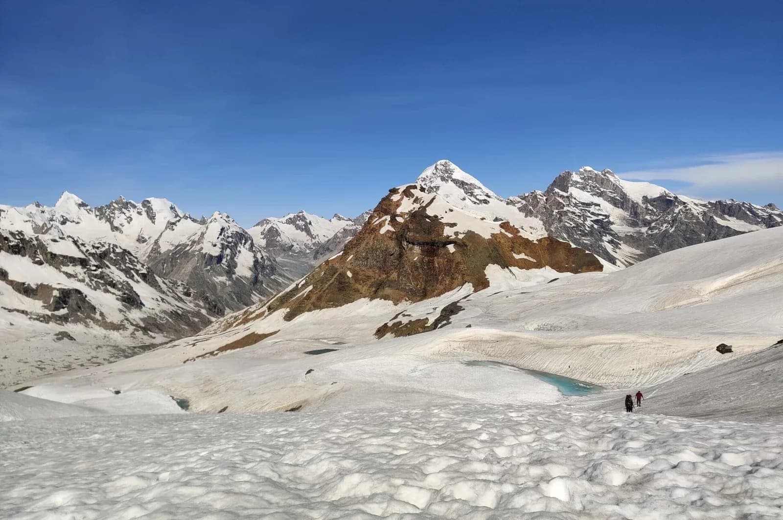
While Kareri Lake serves as a highly popular weekend trek for beginners, Minkiani Pass is the severe, logical conclusion for serious alpine trekkers. Sitting at a towering 14,000 feet directly above Kareri Lake, Minkiani acts as a formidable granite notch in the massive Dhauladhar wall, serving as a historical shepherd's crossover from the Kangra valley into the remote Chamba interior. The trek demands aggressive ascending over loose scree, highly technical boulder-hopping, and crossing steep snow gullies even in early summer. The reward from the pass is an unbroken, shocking panorama of the Pir Panjal range to the north and the sprawling green Kangra plains 10,000 feet directly below to the south. It is an intense, high-altitude punch perfect for those seeking serious adventure over a long weekend.
Ready to book? Compare verified operators for Minkiani Pass Trek — transparent pricing, no paid rankings.
Quick Facts
Duration
Max Altitude
Difficulty
Best Time
Trek Distance
Trail Atmosphere
Stargazing
Class 2 Dark Sky
Scent Profile
Silence Level
~15 dB
Vertigo Factor
4 / 10
Primarily a joint & muscle impact and altitude exposure challenge
A capable trekker's route dominated by extreme joint & muscle impact.
Iconic Spots
The Notch
Getting There
Route to Base
Fly to Kangra (Gaggal) or bus to Dharamshala
Take a local taxi for the 1.5-hour drive to Kareri Village
Base Village
Kareri Village
6,200 ft
Nearest Railhead
Pathankot
Nearest Airport
Kangra (Gaggal)
Last ATM
Dharamshala / McLeodganj
Nearest Medical Facility
Zonal Hospital Dharamshala
Mobile Signal
Drops at the lake. Sometimes pings a notification directly at the summit.
Water Sources
Nyund River until the lake. Zero water on the pass summit day.
Charging
Zero.
For Drivers
Road Condition
Well paved from Dharamshala to Kareri Village.
Dharamshala
Trail Culinary & Diet
Don't miss the N/A
Buy specialized diet items at McLeodganj
The Content & Remote Hub
Top Vlog Spots
Video Calls
none
Est. 0 Mbps
UPI Reliability
1/10
Guide Wisdom
Caution
On the descent from the pass, do not march directly behind someone else. If they dislodge a rock, it acts like a missile down the scree slope.
Explore In Detail
Day by Day Itinerary
4-day route reaching 14,000ft. Covers 37km of varied terrain.
→ See full itinerary with altitude profileDifficulty & Fitness
Rated moderate. The pass approach is infamous. There is no 'trail' in the traditional sense, just a massive wall of boulders that you must scramble up.
→ See difficulty breakdown and fitness guideCost & Pricing
Packages range from ₹5,500 - ₹11,000. Inclusions and hidden costs vary by operator tier.
→ See full cost breakdownPermits and Regulations
Standard forest division permits from Dharamshala are required. Ensure your outfitter handles this.
Learn more about how we vet operators and ensure transparency on our why MountRoutes page.
Packing List
High Alpine Insulation
- Premium down jacket (-10°C to -15°C rating)
- Heavy windproof shell (The pass acts as a massive wind funnel)
- Waterproof trekking pants
Technical Negotiating Gear
- Sturdy high-ankle trekking boots (Sneakers will get shredded on the granite boulders)
- Microspikes / Crampons (Absolutely mandatory if crossing in May or early June)
- Trekking poles (For stability on the treacherous descent)
Flora & Fauna
Flora
Fauna
The pass is an ancient trade and herding route that served the Gaddi shepherds long before trekking became a sport.
— Local folklore
Spiritual & Cultural Significance
Kareri Lake has a Shiva temple on its banks.
🕐 Shrine Timings: Always open
Temple Protocols
- •Do not bathe in the lake near the temple
Frequently Asked Questions
Is this harder than Indrahar Pass?
They are very comparable. Both are steep Dhauladhar passes involving grueling boulder climbs. Minkiani is slightly less crowded than Indrahar.
Do I need technical climbing gear?
Usually no, unless you attempt it too early (April/May) when the snow is deep and icy. In September, it is purely a stamina-based rock scramble.
Can I do it as a day hike from Kareri Lake?
Yes. Most trekkers camp at Kareri Lake, make a massive 12-hour round-trip push to Minkiani Pass and back to the lake on day 2 or 3.
Do I have to cross over to Chamba?
No. You can treat it as a summit hit-and-return to Kareri Lake, or if you have the logistics prepared, cross over entirely to Chamba via the Seven Lakes (Lama Dal).
Is there altitude sickness?
Yes. At 14,000 feet, AMS is a real risk. If you try to push from Dharamshala to the pass in 2 days without resting properly at Kareri, you will likely suffer.
Will there be snow?
You are almost guaranteed to encounter snow patches near the top of the pass until late July.
Is it safe from wild animals?
The lower forests near Kareri have Himalayan Black Bears. Stay with your group during the forest ascent.
Are there water sources on the climb to the pass?
Very few directly on the boulder fields. You must fill up at Kareri Lake before starting the ascent.
Is there mobile signal?
Signal cuts out near Kareri Lake. Strangely, if you stand at the absolute summit of Minkiani Pass, you can sometimes pick up Jio signals bouncing from Kangra.
Can beginners do this?
No. The boulder fields and scree slopes are incredibly steep and punishing. You must have prior high-altitude trekking experience.
Other Treks Guides
Still deciding?
Compare routes side-by-side to find the perfect match for your fitness, dates, and budget.
Everything you need to know, in one place. Someone else in your group needs to see this.
Planning Minkiani Pass Trek?
Get route conditions, operator updates, and season windows before booking.
No spam. Only useful updates.
Ready to walk this route?
You’ve read the guide, now find the perfect local team to take you there. Compare our verified list of operators.
Compare verified operators