
Explore
Intelligence
Essential Planning Guide
Marinda Tal Trek — Complete Guide (2026)
Vibe & Scenery
The Experience
Introduction
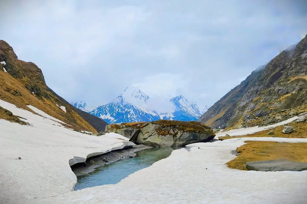
Marinda Tal is a beautiful high-altitude lake tucked away above the Har Ki Dun valley in western Garhwal. While most trekkers end their journey at Har Ki Dun, those who continue towards Marinda Tal are rewarded with a far quieter landscape dominated by alpine meadows, glacial streams, and the towering Swargarohini massif.
The trail follows the Supin River before leaving the main valley to climb across rocky terrain and seasonal stream crossings towards the lake. As elevation increases, forests gradually give way to open alpine country where dramatic mountain walls surround the basin.
Although often completed as an extension of Har Ki Dun rather than an independent expedition, Marinda Tal offers a distinctly different experience. The route feels more remote, receives far fewer visitors, and rewards trekkers with one of Garhwal's lesser-known alpine lakes.
Quick Facts
Duration
Max Altitude
Difficulty
Best Time
Trek Distance
Trail Atmosphere
Stargazing
Class 1 Dark Sky
Scent Profile
Silence Level
~30 dB
Vertigo Factor
2 / 10
Iconic Spots
Har Ki Dun Amphitheater
Marinda Tal
Environment
Nature & Culture
Flora & Fauna
Flora
Fauna
The Har Ki Dun valley is known as the 'Valley of Gods'. Locals believe it is the route the Pandavas took to ascend to heaven (Swargarohini).
— Local folklore
Spiritual & Cultural Significance
Osla village has a temple dedicated to Someshwar (Shiva), though historically linked to Duryodhana.
Temple Protocols
- •Do not wear leather belts or shoes inside temple premises in Osla.
Technical Details
Challenge & Preparation
Primarily a cardio demand challenge
A capable trekker's route that balances cardio demand and cumulative fatigue.
Personal Readiness
Am I ready?
Planning
Logistics & Trail Intel
Getting There
Route to Base
Take an overnight train or bus to Dehradun
From Dehradun railway station, shared cabs and buses leave for Sankri early in the morning (6-8 AM)
Base Village
Sankri
6,455 ft
Last ATM
Purola (Cash is mandatory in Sankri)
Nearest Medical Facility
Primary Health Centre in Purola
Mobile Signal
None past Sankri.
Water Sources
Abundant. The trail runs parallel to the Supin River, and there are numerous clean mountain streams.
Charging
Only in Sankri. Occasionally available in Osla homestays via solar, but unreliable.
For Drivers
Road Condition
The mountain roads from Dehradun to Sankri are scenic but narrow. Motion sickness tablets are recommended.
Purola
Trail Culinary & Diet
Don't miss the Red Rice and Rajma in Sankri.
Buy specialized diet items at Dehradun
The Content & Remote Hub
No DronesProhibited inside Govind Pashu Vihar National Park.Top Vlog Spots
Video Calls
none
Est. 0 Mbps
UPI Reliability
1/10
Permits and Regulations
The trek falls entirely within the Govind Pashu Vihar National Park. Entry permits are mandatory and are issued at the Forest Department checkpoint in Netwar. Drones are strictly prohibited inside the park limits.
Learn more about how we vet operators and ensure transparency on our why MountRoutes page.
Packing List
Clothing & Outerwear
- Heavy down jacket (rated for -5°C)
- Waterproof and windproof hardshell jacket
- Trekking pants (2 pairs) and waterproof over-trousers
- Thermal baselayers (top and bottom)
- Fleece mid-layer
- Warm fleece beanie and sun hat
- Waterproof trekking gloves
Footwear
- High-ankle waterproof trekking boots
- Camp shoes or sturdy sandals
- 3-4 pairs of woolen trekking socks
- Microspikes (if trekking in early May or late Nov)
Gear & Accessories
- 40-50L trekking backpack with rain cover
- Trekking poles
- Headlamp with extra batteries
- UV protection sunglasses
- Insulated water bottle (1L - 2L)
Health & Hygiene
- Personal First Aid Kit (including Diamox)
- High SPF (50+) sunscreen and SPF lip balm
- Biodegradable wet wipes and hand sanitizer
- Water purification tablets
- Personal toiletries and blister tape
Deep Dives
Explore Further
Editor's Notes
Explore In Detail
Day by Day Itinerary
7-day route reaching 12,800ft. Covers 50.0km of varied terrain.
→ See full itinerary with altitude profileDifficulty & Fitness
Rated moderate. The trail is predominantly a well-trodden forest and meadow path. The 3km extension from Har Ki Dun to Marinda Tal is slightly rockier and involves a moderate climb.
→ See difficulty breakdown and fitness guideCost & Pricing
Packages range from ₹8,500 - ₹12,000. Inclusions and hidden costs vary by operator tier.
→ See full cost breakdownFrequently Asked Questions
Is Marinda Tal the same as Har Ki Dun?
No. Har Ki Dun is the main valley. Marinda Tal is a high-altitude glacial lake situated about 3 km further ahead of the Har Ki Dun valley campsite.
Can a beginner do the Marinda Tal trek?
Yes. The trek is rated as Easy to Moderate. The trail is well-defined and the altitude gain is gradual, making it suitable for fit beginners.
Do I need technical gear for this trek?
Generally, no. However, if you are trekking in early May or late November, microspikes and gaiters might be required to negotiate lingering snow near the lake.
Will I get mobile network on the trail?
You will get patchy BSNL network in Sankri and sometimes near Purola. Beyond Sankri, there is absolutely no mobile network.
Can I do this trek in the monsoon?
It is not recommended. The Govind Pashu Vihar region experiences heavy rainfall in July and August, leading to muddy trails, leeches, and a high risk of landslides on the road to Sankri.
Are there homestays on the trail?
Yes, there are wooden homestays available in the ancient villages of Osla and Gangaad. However, near Har Ki Dun and Marinda Tal, you will need to camp.
Is it safe for solo female travelers?
Yes, if trekking with a registered agency or a certified local guide. The trail is quite popular, but solo hiking without a local guide in the National Park is restricted.
What is the Brahma Kamal?
The Brahma Kamal is a rare, highly revered high-altitude flower native to the Himalayas. It blooms around Marinda Tal during the late summer months.
Still deciding?
Compare routes side-by-side to find the perfect match for your fitness, dates, and budget.
Everything you need to know, in one place. Someone else in your group needs to see this.
Planning Marinda Tal?
Get route conditions, operator updates, and season windows before booking.
Don't miss out! Follow us for route updates@mountroutes|LinkedIn
No spam. Only useful trek updates.
Ready to walk this route?
You’ve read the guide, now find the perfect local team to take you there. Compare our verified list of operators.
Compare verified operators