
Explore
Intelligence
Essential Planning Guide
Chaainsheel Bugyal Trek — Complete Guide (2026)
Vibe & Scenery
The Experience
Introduction
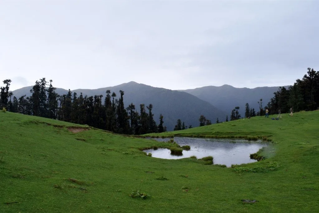
Chaainsheel Bugyal is one of the Garhwal Himalayas' least-visited high-altitude meadow systems, stretching across the ridges near the Uttarakhand–Himachal Pradesh border. The trek combines dense deodar and rhododendron forests, traditional mountain villages, and expansive alpine grasslands that have long served as seasonal grazing grounds.
As the trail climbs above the tree line, wide ridgelines reveal sweeping views of Swargarohini, Bandarpoonch, Draupadi Ka Danda, and neighbouring Himalayan peaks. Unlike many well-known bugyal treks, Chaainsheel retains a peaceful atmosphere throughout the season, making it ideal for trekkers who value solitude as much as scenery.
Moderate gradients, extended meadow walking, and rewarding campsites make this a satisfying multi-day trek for hikers with reasonable fitness.
Quick Facts
Duration
Max Altitude
Difficulty
Best Time
Trek Distance
Trail Atmosphere
Stargazing
Class 2 Dark Sky
Scent Profile
Silence Level
~25 dB
Vertigo Factor
1 / 10
Iconic Spots
Chaainsheel Ridge
Akhoti Thach
Tons Valley Drive
Environment
Nature & Culture
Flora & Fauna
Flora
Fauna
The high meadows are shared grazing grounds for shepherds from both Uttarakhand and Himachal, maintaining a peaceful, cross-border pastoral culture.
— Local folklore
Spiritual & Cultural Significance
The region is steeped in Mahabharata lore, with the nearby Swargarohini peak believed to be the stairway to heaven.
Temple Protocols
Technical Details
Challenge & Preparation
Primarily a joint & muscle impact and cardio demand challenge
A capable trekker's route that balances joint & muscle impact and cardio demand.
Personal Readiness
Am I ready?
Planning
Logistics & Trail Intel
Getting There
Route to Base
Take an overnight train/bus to Dehradun
From Dehradun, it is a 9-hour drive via Mussoorie and Purola to Himari
Base Village
Himari / Balawat
5,500 ft
Last ATM
Purola
Nearest Medical Facility
Primary Health Centre, Purola.
Mobile Signal
Total blackout after Himari.
Water Sources
Forest streams provide abundant water up to Gujar Hat. The high bugyals are dry.
Charging
Total blackout.
For Drivers
Road Condition
Dehradun to Mussoorie is excellent. Mussoorie to Purola is good. The final stretch to Himari can be bumpy.
Purola
Trail Culinary & Diet
Don't miss the Garhwali Rajma in Himari
Buy specialized diet items at Dehradun
The Content & Remote Hub
Top Vlog Spots
Video Calls
base_village_only
Est. 5 Mbps
UPI Reliability
4/10
Permits and Regulations
Standard Govind Pashu Vihar National Park / Uttarkashi Forest Department permits are required. Operators usually arrange these at the Mori forest checkpoint.
Learn more about how we vet operators and ensure transparency on our why MountRoutes page.
Packing List
Clothing
- Fleece jacket or warm sweater
- Waterproof outer shell (Poncho or Gore-Tex jacket)
- Thermal inner wear (1 set for sleeping)
- Quick-dry trekking trousers (x2)
- Lightweight down jacket for the bugyal camp
Footwear & Protection
- High-ankle trekking boots (waterproof recommended)
- Merino wool socks (x3 pairs)
- Camp shoes (lightweight sneakers)
- Sun hat with neck flap
Camping & Gear
- 40-50L backpack with rain cover
- Trekking poles (essential for forest descents)
- 3-season sleeping bag (-5°C rating)
- Headlamp with spare batteries
Health & Essentials
- Personal first aid kit (Diamox, blister tape)
- Sunscreen (SPF 50+) and lip balm
- 2L water bottles or hydration bladder
- Original ID card and photocopies
Deep Dives
Explore Further
Editor's Notes
Explore In Detail
Day by Day Itinerary
6-day route reaching 11,750ft. Covers 40.0km of varied terrain.
→ See full itinerary with altitude profileDifficulty & Fitness
Rated moderate. The trail is a classic mix of steep, root-covered forest floor at the lower elevations, transitioning to soft, rolling alpine grass at the bugyals.
→ See difficulty breakdown and fitness guideCost & Pricing
Packages range from 8,500 - 11,000 INR (Dehradun to Dehradun). Inclusions and hidden costs vary by operator tier.
→ See full cost breakdownFrequently Asked Questions
Is Chaainsheel Bugyal suitable for beginners?
Yes. It is graded as Easy to Moderate. The altitude gain is gradual, and the trails through the forest and meadows are well-defined. It is an excellent choice for fit beginners and active families.
How does it compare to Dayara Bugyal?
Dayara is a very popular, commercialized meadow. Chaainsheel is much more remote, requiring a longer drive to the base camp (Himari). You will experience far greater solitude at Chaainsheel.
What mountains can I see from the meadow?
On a clear day, you have a massive 180-degree view of the Garhwal and Kinnaur ranges, including Swargarohini, Bandarpunch, Black Peak, and Draupadi Ka Danda.
Will I have mobile network?
You will have patchy network (BSNL/Jio) during the drive up to Himari/Arakot. Once the trek begins, expect a total network blackout until you return to the base village.
Is there snow on the trail?
If you trek in early May, you will find residual snow patches in the higher meadows. During the post-monsoon season (September-October), the trail is completely dry.
Are there leeches on the trail?
If you trek in the late monsoon (August) or early September, the damp forest sections below 9,000 ft can have leeches. Wear high socks and keep moving.
Can I do this trek independently?
While it is physically moderate, the trails are used by local shepherds and are not signposted. It is highly recommended to hire a local guide from Himari to navigate the forest sections safely.
Where does the trek start?
The trek typically starts from the village of Himari or Balawat, which are accessed via a long 8-9 hour drive from Dehradun through the Tons river valley.
Still deciding?
Compare routes side-by-side to find the perfect match for your fitness, dates, and budget.
Everything you need to know, in one place. Someone else in your group needs to see this.
Planning Chaainsheel Bugyal Trek?
Get route conditions, operator updates, and season windows before booking.
Don't miss out! Follow us for route updates@mountroutes|LinkedIn
No spam. Only useful trek updates.
Ready to walk this route?
You’ve read the guide, now find the perfect local team to take you there. Compare our verified list of operators.
Compare verified operators