
Explore
Intelligence
Essential Planning Guide
Rishikund Trek — Complete Guide (2026)
Vibe & Scenery
The Experience
Introduction
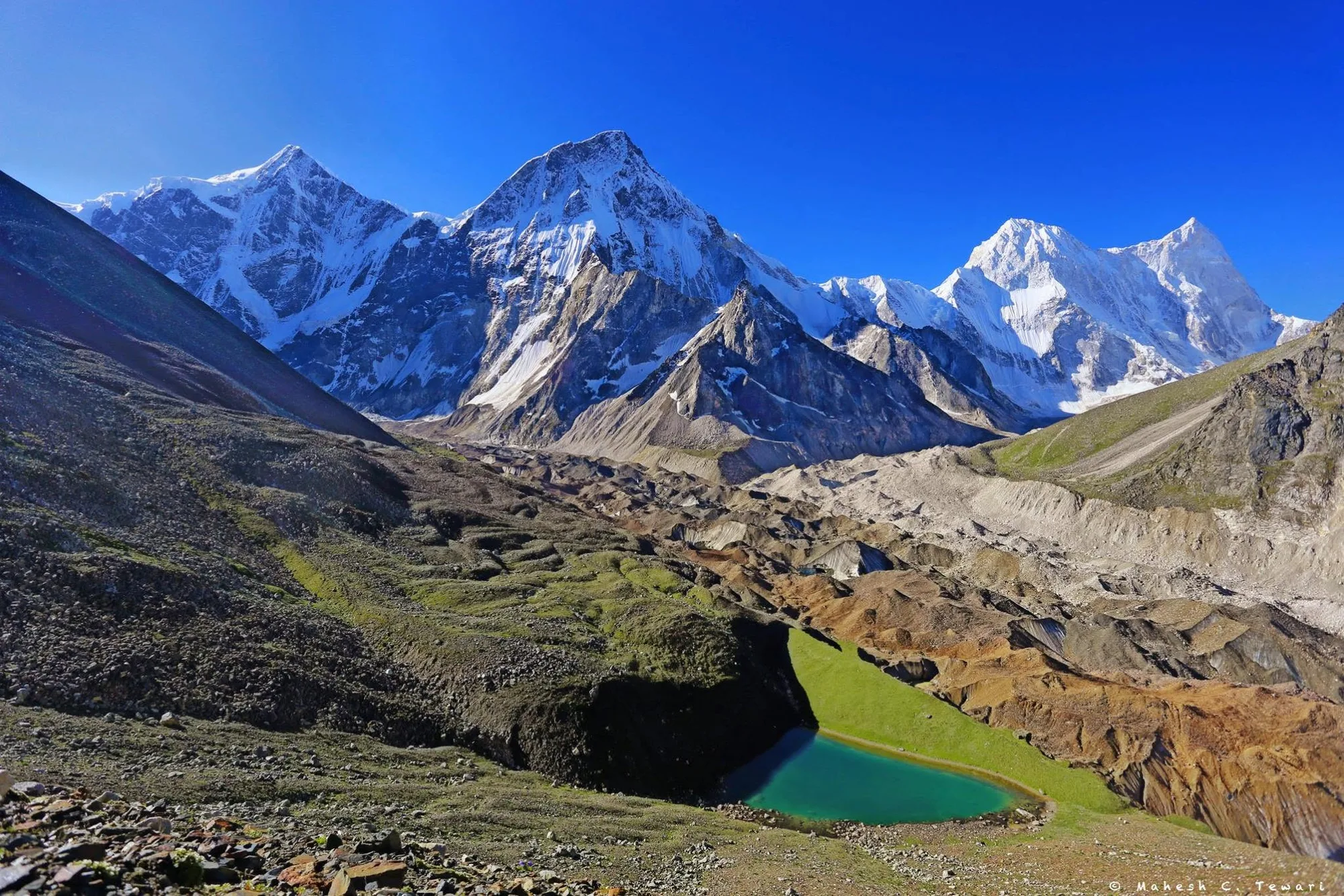
Hidden within the upper reaches of the Nanda Devi Biosphere Reserve, Rishikund is a quiet alpine lake reached by one of Garhwal's lesser-known trekking routes. Unlike the similarly named sacred pond in Rishikesh, this Rishikund lies deep within the mountains near Joshimath and attracts very few trekkers.
The trail climbs gradually through traditional villages, dense forests of cedar and rhododendron, and broad alpine meadows before reaching the glacial lake at approximately 14,337 ft. Along the way, expansive views unfold towards Nanda Devi, Dronagiri, Trishul, Nandaghunti, and other iconic Kumaon and Garhwal peaks.
The combination of moderate altitude, remote campsites, and limited visitor numbers gives Rishikund a distinctly peaceful character. It is an excellent choice for trekkers seeking solitude and mountain scenery beyond Uttarakhand's better-known trekking circuits.
Quick Facts
Duration
Max Altitude
Difficulty
Best Time
Trek Distance
Trail Atmosphere
Stargazing
Class 1 Dark Sky
Scent Profile
Silence Level
~30 dB
Vertigo Factor
4 / 10
Iconic Spots
Kantala Bugyal
Rishikund Lake
Environment
Nature & Culture
Flora & Fauna
Flora
Fauna
The Nanda Devi Biosphere is deeply sacred to locals, believed to be the abode of Goddess Nanda. The lake is considered pure, and washing clothes in it is forbidden.
— Local folklore
Spiritual & Cultural Significance
The entire Nanda Devi region is considered sacred. The lake is respected as a pure natural site.
Temple Protocols
- •Maintain silence and cleanliness near the lake.
Technical Details
Challenge & Preparation
Primarily a joint & muscle impact and cumulative fatigue challenge
A demanding expedition that balances joint & muscle impact and cumulative fatigue.
Personal Readiness
Am I ready?
Planning
Logistics & Trail Intel
Getting There
Route to Base
Overnight train or bus to Haridwar/Rishikesh, followed by a 10-hour drive (shared cab or bus) to Joshimath
Base Village
Joshimath
6,150 ft
Last ATM
Joshimath
Nearest Medical Facility
Community Health Centre (CHC) in Joshimath
Mobile Signal
None past Suraithota.
Water Sources
Natural springs and streams along the forest and meadow sections. The lake provides water at the top camp.
Charging
Available only in Joshimath.
For Drivers
Road Condition
The highway to Joshimath is generally good, though susceptible to monsoon landslides.
Joshimath
Trail Culinary & Diet
Don't miss the Garhwali Dal Chainsoo available in Joshimath.
Buy specialized diet items at Rishikesh / Dehradun
The Content & Remote Hub
No DronesDrones are strictly prohibited inside the Nanda Devi Biosphere Reserve.Top Vlog Spots
Video Calls
none
Est. 0 Mbps
UPI Reliability
2/10
Base WiFi Available
Permits and Regulations
Permits are mandatory as the trek falls within the Nanda Devi Biosphere Reserve buffer zone. These must be obtained from the Forest Department office in Joshimath. Strict Leave No Trace policies apply, and campfires are strictly prohibited.
Learn more about how we vet operators and ensure transparency on our why MountRoutes page.
Packing List
Clothing & Outerwear
- Heavy down jacket (rated for -5°C to -10°C)
- Waterproof and windproof hardshell jacket
- Trekking pants (2 pairs) and waterproof over-trousers
- Thermal baselayers (top and bottom)
- Fleece mid-layer or woolen sweater
- Warm fleece beanie and sun hat
- Waterproof trekking gloves and inner fleece gloves
Footwear
- High-ankle waterproof trekking boots with good grip
- Camp shoes or sturdy sandals
- 3-4 pairs of woolen trekking socks
- 2 pairs of moisture-wicking liner socks
Gear & Accessories
- 40-50L trekking backpack with rain cover
- Trekking poles (highly recommended for steep ascents)
- Headlamp with extra batteries
- Category 3 or 4 UV protection sunglasses
- Insulated water bottle or hydration bladder (2L capacity)
Health & Hygiene
- Personal First Aid Kit (including Diamox for AMS)
- High SPF (50+) sunscreen and SPF lip balm
- Biodegradable wet wipes and hand sanitizer
- Water purification tablets or Lifestraw
- Personal toiletries and blister tape/moleskin
Deep Dives
Explore Further
Editor's Notes
Explore In Detail
Day by Day Itinerary
8-day route reaching 14,337ft. Covers 47.0km of varied terrain.
→ See full itinerary with altitude profileDifficulty & Fitness
Rated challenging. The trail transitions from village paths to steep forest trails, opening into expansive meadows. The final push to the lake involves navigating rocky, scree-covered terrain.
→ See difficulty breakdown and fitness guideCost & Pricing
Packages range from ₹15,000 - ₹22,000+. Inclusions and hidden costs vary by operator tier.
→ See full cost breakdownFrequently Asked Questions
Is this trek the same as Rishikund in Rishikesh?
No. Rishikund in Rishikesh is a hot water spring and religious site located in the city. The Rishikund Trek is a high-altitude wilderness trek near Joshimath in the Nanda Devi Biosphere Reserve, reaching over 14,000 ft.
How difficult is the Rishikund Trek?
The trek is rated as Moderate to Challenging. While it doesn't require technical mountaineering skills, the steep daily altitude gains and the maximum altitude of 14,337 ft demand high physical fitness and proper acclimatization.
Do I need a guide for this trek?
Yes. The trail is remote, uncommercialized, and passes through the Nanda Devi Biosphere buffer zone. A local guide is essential for route finding, managing forest permits, and safety.
Will I get mobile network on the trail?
Mobile connectivity is extremely limited. You may get patchy BSNL network in Joshimath and Suraithota, but expect zero connectivity from Bhallagaon onwards.
Can beginners do the Rishikund Trek?
It is not recommended as a first trek. Beginners should first complete a few Himalayan treks reaching 10,000–12,000 ft before attempting this route due to its isolation and altitude.
Are there teahouses on the way?
No. Beyond the initial villages, this is a fully self-contained camping trek. You must carry all tents, sleeping bags, and food rations.
What kind of wildlife might we encounter?
The trek is in a protected biosphere. Trekkers often spot Himalayan Monal (state bird), Blue Sheep (Bharal), and occasionally Himalayan Black Bears or signs of Snow Leopards.
Is Diamox necessary for this trek?
Given the altitude of over 14,000 ft, carrying Diamox is highly recommended. Consult your physician regarding dosage before starting the trek.
Still deciding?
Compare routes side-by-side to find the perfect match for your fitness, dates, and budget.
Everything you need to know, in one place. Someone else in your group needs to see this.
Planning Rishikund Trek?
Get route conditions, operator updates, and season windows before booking.
Don't miss out! Follow us for route updates@mountroutes|LinkedIn
No spam. Only useful trek updates.
Ready to walk this route?
You’ve read the guide, now find the perfect local team to take you there. Compare our verified list of operators.
Compare verified operators