
Explore
Intelligence
Essential Planning Guide
Monal Top Trek — Complete Guide (2026)
Vibe & Scenery
The Experience
Introduction
Beginning from Wan village, the traditional gateway to Roopkund, the Monal Top Trek follows lesser-used forest trails through dense oak and rhododendron woodland before emerging onto open alpine ridges near the summit.
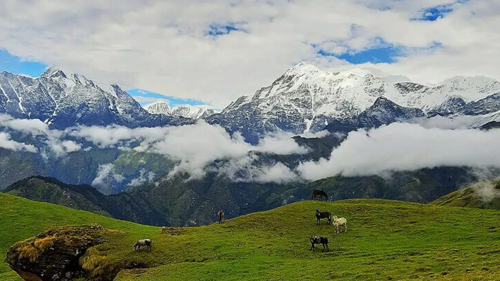
From Monal Top, trekkers enjoy wide views of Trishul, Nanda Ghunti, Chaukhamba, and other peaks across the Garhwal Himalayas. During spring, blooming rhododendrons transform the forests into one of the region's most colourful trekking landscapes.
Moderate altitude, peaceful campsites, and excellent mountain panoramas make Monal Top well suited to trekkers looking beyond Uttarakhand's more established routes.
Quick Facts
Duration
Max Altitude
Difficulty
Best Time
Trek Distance
Trail Atmosphere
Stargazing
Class 3 Dark Sky
Scent Profile
Silence Level
~30 dB
Vertigo Factor
3 / 10
Iconic Spots
Wan Village
Suneli Dhar Forest
Monal Top Summit
Environment
Nature & Culture
Flora & Fauna
Flora
Fauna
Wan village is steeped in the mythology of Nanda Devi. The Latu Devta temple in the village is considered the gateway where pilgrims pay respects before heading higher into the mountains.
— Local folklore
Spiritual & Cultural Significance
Wan village is a critical stop on the Nanda Devi Raj Jat Yatra. The local Latu Devta temple is highly revered.
🕐 Shrine Timings: N/A
Temple Protocols
- •Maintain respectful attire if visiting the Latu Devta temple before the trek
Festivals & Dates
Technical Details
Challenge & Preparation
Primarily a cardio demand challenge
A welcoming route that balances cardio demand and cumulative fatigue.
Personal Readiness
Am I ready?
Planning
Logistics & Trail Intel
Getting There
Route to Base
Wan is located about 15 km beyond Lohajung
The drive from Dehradun (280 km) takes 10 hours
Shared taxis run regularly from Dehradun/Rishikesh to Karnaprayag and Tharali, from where local cabs go to Lohajung and Wan
Base Village
Wan Village
8,000 ft
Last ATM
Dewal / Tharali
Nearest Medical Facility
Primary Health Centre in Lohajung.
Mobile Signal
Zero signal on the trail. Emergency comms rely on VHF or satellite if carried.
Water Sources
Natural streams available near Wan and Suneli Dhar. During peak winter, upper streams freeze; operators will melt snow. Carry 2L daily.
Charging
None after Wan village.
For Drivers
Road Condition
Dehradun to Karnaprayag is a well-maintained highway. The final stretch from Dewal to Wan is a narrower, bumpier mountain road.
Karnaprayag / Tharali
Trail Culinary & Diet
Don't miss the Garhwali Rajma and Rice
Buy specialized diet items at Dehradun / Rishikesh
The Content & Remote Hub
Top Vlog Spots
Video Calls
low
Est. 5 Mbps
UPI Reliability
8/10
Base WiFi Available
Permits and Regulations
Trekking in this region requires forest permits from the Dewal forest range office. Since it is close to the Nanda Devi buffer and Roopkund trail, ID proofs and signed medical certificates are strictly enforced by the forest department.
Learn more about how we vet operators and ensure transparency on our why MountRoutes page.
Packing List
Core Clothing Layers
- Dry-fit thermals (top and bottom, x2)
- Heavy fleece jacket for mid-layer insulation
- Down jacket (rated to -10°C) for winter summit push
- Windproof and waterproof shell jacket (Gore-Tex or equivalent)
- Trekking pants (quick-dry, x2)
- Waterproof snow pants (mandatory for Jan-March)
Footwear & Protection
- High-ankle waterproof trekking boots with deep lugs
- Merino wool trekking socks (x4 pairs) and liner socks
- Microspikes/crampons (mandatory for winter snow)
- Knee-high waterproof gaiters for deep snow sections
- Camp sandals or insulated booties
Head & Hands
- Fleece beanie covering ears
- Balaclava or neck gaiter for wind protection
- UV-protection sunglasses (Category 3/4) to prevent snow blindness
- Thin fleece liner gloves
- Heavy waterproof insulated outer gloves
Gear & Accessories
- 50-60 litre ergonomic backpack with rain cover
- Trekking poles (mandatory pair with snow baskets)
- Headlamp with spare lithium batteries
- Insulated thermos flask (1L) to prevent water from freezing
- Personal medical kit (Diamox, blister tape, painkillers)
- High-energy trail mix and electrolyte sachets
Deep Dives
Explore Further
Editor's Notes
Explore In Detail
Day by Day Itinerary
5-day route reaching 12,100ft. Covers 19.0km of varied terrain.
→ See full itinerary with altitude profileDifficulty & Fitness
Rated accessible. The trail is largely well-defined through forests in the lower sections. Above Suneli Dhar, the path becomes a snow-covered alpine ridge in winter, requiring gaiters and microspikes to prevent slipping.
→ See difficulty breakdown and fitness guideCost & Pricing
Packages range from 7,500 - 9,500 INR. Inclusions and hidden costs vary by operator tier.
→ See full cost breakdownFrequently Asked Questions
Why should I choose Monal Top over Brahmatal or Kedarkantha?
Monal Top offers the exact same altitude profile (12,100 ft) and similar snow conditions as Kedarkantha and Brahmatal, but without the massive commercial crowds. You get a pristine, isolated wilderness experience while still enjoying massive views of Mt. Trishul.
Is the Monal Top trek safe for beginners?
Yes, it is graded as Easy to Moderate. The altitude gain is steady and there are no highly technical sections. However, during the winter months, trekking in snow requires good baseline fitness and proper layering.
What is the trail condition from Wan to Suneli Dhar?
The trail climbs steadily through extremely dense oak and rhododendron forests. It is an unpaved, natural forest floor which can be slippery when wet or covered in hard-packed snow.
Will I need microspikes or gaiters?
If you are trekking between late December and March, microspikes and gaiters are absolutely mandatory to safely negotiate the hard snow near the summit and prevent snow from entering your boots.
How cold does it get at the high camps?
During peak winter (Jan-Feb), daytime temperatures range from 5°C to 12°C, but nighttime temperatures at Kukina Khal and Suneli Dhar can drop to -5°C to -10°C.
Where is the nearest medical facility?
The nearest Primary Health Centre is in Lohajung (about an hour from Wan). For serious emergencies or severe AMS, the nearest major hospital is in Karnaprayag, which is a 4-5 hour drive from the base camp.
Is there mobile network connectivity on the trek?
You will get decent mobile networks (Jio, Airtel, BSNL) in Lohajung and sporadically in Wan village. Once you enter the forest towards Suneli Dhar, you will lose all connectivity until you return.
Can I see the Monal bird on this trek?
Yes, the trek is named after the Himalayan Monal (the state bird of Uttarakhand). While elusive, early risers in the quieter forest sections have a good chance of spotting this incredibly colorful bird.
Still deciding?
Compare routes side-by-side to find the perfect match for your fitness, dates, and budget.
Everything you need to know, in one place. Someone else in your group needs to see this.
Planning Monal Top Trek?
Get route conditions, operator updates, and season windows before booking.
Don't miss out! Follow us for route updates@mountroutes|LinkedIn
No spam. Only useful trek updates.
Ready to walk this route?
You’ve read the guide, now find the perfect local team to take you there. Compare our verified list of operators.
Compare verified operators