Explore
Intelligence
Detailed Route
Buran Ghati Trek Itinerary — Day by Day Route & Camps
Buran Ghati Trek runs Janglik to Litham in 7 days — the 15,000ft glacier pass crossing hits on Day 6.
Standard RouteThis is the standard mountain pacing for this trek. Specific operators may add an acclimatization day or alter the starting point. Check individual operator schedules for their exact logistics.
Duration
7 Days
Total Distance
48 KM
Max Altitude
15,000 FT
Trek Type
linear
Day by Day Breakdown
Camp Alt
9,200 ft
Day Gain
+1,962 ft
Drive to Janglik
Homestay in Janglik. Expedition briefing. Technical: 8-hour drive through the Pabbar Valley. Road quality deteriorates after Rohru. The last 20 km to Janglik is a rough dirt track. Carry snacks for the drive. Landscape: Janglik is a remote Himalayan village with traditional slate-roofed houses. The village has a sacred temple dedicated to Shikari Devi. It's the kind of village where life moves to the rhythm of seasons, not clocks.
Key Landmarks
The motorable road navigates deeper into the mountain river corridor, where the landscape transitions from lower foothills into the steep, dense forested valleys.
Camp Alt
11,000 ft
Day Gain
+1,800 ft
Reach Dayara Thach
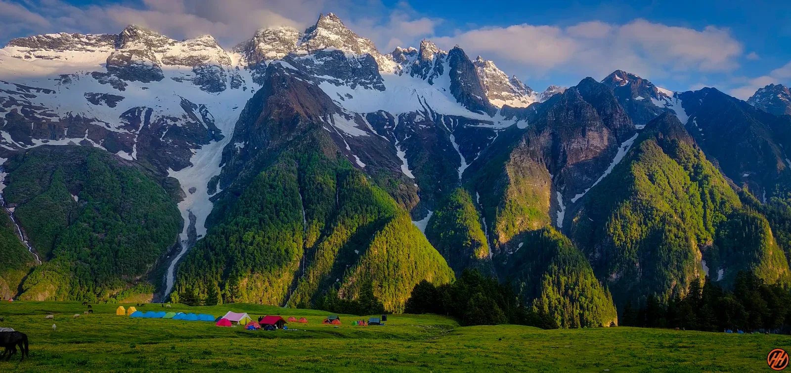
Tent camp. The meadow is wide and beautiful. Stars are extraordinary. Technical: Steep climb through thick forest. You gain nearly 5,000 ft today — the biggest single-day gain. Pace is critical. The trail transitions from forest to open meadow at Dayara Thach. Landscape: Dayara Thach is a vast alpine meadow used by Gaddi shepherds. In June-July, it transforms into a carpet of wildflowers — irises, primulas, and potentillas. Safety: Major altitude jump. Hydrate 4L+. Oximeter check at camp.
Key Landmarks
Staying At
The Janglik settlement emerges onto a forested ascent toward the Dayara Thach meadow.
Camp Alt
11,800 ft
Day Gain
+800 ft
Reach Litham via Chandranahan Lakes
Camp at Litham. Visit to the lakes is a side-trip from camp. Technical: The climb to the lakes is steep and rocky. Chandranahan Lakes are a series of 7 glacial lakes, of which 2-3 are typically accessible. The upper lake is sacred — no bathing or washing. The entire area is a glacial cirque. Landscape: Chandranahan means 'moon-bathed'. The lakes are believed to have been created by the tears of the moon goddess. They are the source of the Pabbar River. Locals from Janglik and Chirgaon consider these lakes the most sacred water bodies in the Shimla Hills. Safety: 12,100ft. AMS check. Wind at the lakes can be extreme. Layer up. Do not stay above the lakes after 3 PM.
Key Landmarks
Staying At
Crossing the high-altitude pass bridges two distinct watershed systems, shifting the expedition over the glaciated divide and down into a new river basin.
Field Notes
KEY ACTIONRiver Crossings
Plan to cross early in the day before snowmelt swells the water levels. Unclip backpack waist belts before crossing.
Camp Alt
13,500 ft
Day Gain
+1,700 ft
Reach Buran Base Camp
Base camp night. Early sleep for the 4 AM start. Technical: Walking on snow from today. The trail is unmarked above the lakes. Follow cairns and guide markers. Dhunda is a flat, wind-exposed campsite at the base of the pass wall. Safety: Critical AMS check. 13,500ft with sub-zero temperatures. Carry warm water in thermal flasks. Summit briefing tonight.
Key Landmarks
Staying At
Vegetation gives way to barren glacial debris as the route enters the expansive moraine basin and ablation zone of the glaciated upper watershed.
Field Notes
Use Trekking Poles
Trekking poles are highly recommended to save your knees on the descent.
INFOSlower Progress
Progress will be significantly slower and more taxing on your ankles than trail distance suggests.
Camp Alt
11,800 ft
Day Gain
-1,700 ft
Today's Objective
🏔 Cross Buran Ghati Pass
Celebration camp at Barua. The hardest part is behind you. Technical: Start at 4 AM. The ascent to the pass is a 3-hour snow walk. The pass crest is narrow. The defining moment: a 70-degree, 200m ice-wall descent on the far side. You are harnessed and roped, and either rappel down or slide (controlled) on the snow face. Guides manage the ropes. It takes 15-20 minutes per person. After the ice wall, a long moraine and boulder descent to Barua. Landscape: The ice-wall descent separates Buran from every other trek in India. It's the moment that makes veterans out of adventurers. Safety: Turnback time: 10 AM. Helmet mandatory for the ice wall. Do not unhook from the rope until the guide signals. Snow instability increases after 11 AM.
Key Landmarks
Staying At
The route crosses the pass crest at Buran Ghati, entering the Manerang valley.
Field Notes
Use Trekking Poles
Trekking poles are highly recommended to save your knees on the descent.
INFOSlower Progress
Progress will be significantly slower and more taxing on your ankles than trail distance suggests.
Camp Alt
6,500 ft
Day Gain
-5,300 ft
Descend to Barua Village
Steep descent through pine and apple orchards down to the Kinnauri village of Barua. Celebrate the crossing.
Key Landmarks
Staying At
Crossing the high-altitude pass bridges two distinct watershed systems, shifting the expedition over the glaciated divide and down into a new river basin.
Camp Alt
7,200 ft
Day Gain
+700 ft
Drive to Shimla
Return drive. Trek concludes.
The motorable road navigates deeper into the mountain river corridor, where the landscape transitions from lower foothills into the steep, dense forested valleys.
Trek Extensions & Add-ons
Chandranahan Lake Acclimatization Hike
+1 DayAdd an extra day at Litham campsite to hike up to all seven sacred high tarns of Chandranahan Lake for pristine high-altitude acclimatization.
Plan Your Trek:
Ready to book? Compare verified operators for Buran Ghati Trek — transparent pricing, no paid rankings.
Still deciding?
Compare routes side-by-side to find the perfect match for your fitness, dates, and budget.
Day by day, camp by camp. Send this to your group so everyone's on the same page.
Step 4: Cost & Logistics
You understand the route.
Now see what services, permits, and logistics actually cost.
View Cost Breakdown