Difficulty & Readiness Guide
Is Bara Shigri Glacier Traverse Expedition Difficult? — Fitness & Altitude Guide
A severe physical challenge navigating 28km of shifting moraine, massive crevasses, and dead ice.
Preparation Required
Advanced
Prior Experience
Required: At least 2-3 moderate Himalayan treks (above 13,000ft).
Score Engine v3
Why This Score?
Stamina
39/100
Based on average nightly altitude gain, highest campsite, and daily distance. Reflects how hard the average day feels.
Spike Day
34/100
Based on max altitude reached, summit day elevation gain, and summit day distance. Reflects the hardest single day.
Why Bara Shigri Glacier Traverse Expedition Feels Difficult
A demanding expedition dominated by extreme altitude exposure.
Physiological Demand
Extreme high altitude exposure. Severe oxygen depletion requires careful acclimatization and peak cardiovascular health.
Multi-day camping requiring mental toughness to handle weather and fatigue debt.
Rough, uneven trails with occasional scrambling or minor exposure.
Challenging daily distances and steady climbs. Good cardiovascular fitness is required.
Rolling or gradual terrain with minimal harsh impact on joints.
Crux Section
Day 4 — Oxygen Peak
Highest exposure point at 16,600ft.
High-Altitude Crossing — Grading Context
At 53/100 on the ExpeditionDifficulty Scale, this is one of India's most demanding high-altitude crossings. Due to the remoteness, sustained altitude, and total daily effort, this crossing demands elite fitness and prior high-altitude experience.
Bara Shigri Glacier Traverse Expedition/ 53
The Snout Warning
Caution
The ice caves at the glacier snout are beautiful but lethal. They collapse without warning — tonnes of ice dropping in seconds. Maintain a 50m safe distance at all times.
Terrain Breakdown
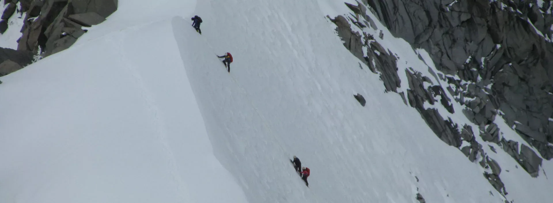
Glacial moraine (loose rock ridges) and glacier surface. No technical climbing but extreme care needed near crevasses.
Preparation
Advanced. Good balance and ankle stability for moraine walking. Altitude tolerance critical.
Altitude Profile
You will be ascending from an base altitude of 12500 ft to 16503 ft.
Run AMS Risk Audit →Route Stress Forecast
Highest exposure point at 16,600ft.
Day 4 requires the highest sustained output.
*Forecast derived from route geometry and altitude profile. External variables (weather/group) remain the final authority.
Trail Performance Data
Max Gradient
45%
Hydration
0.7L per km recommended
Loose Surface Sections
- •Unstable lateral moraine rocks
- •Slippery ice patches with hidden crevasses
Common Mistakes on Bara Shigri Glacier Traverse Expedition
Most injuries and failures on this trail can be avoided by making smarter decisions early on.
Approaching ice caves at the snout.
Walking on blue ice without ropes.
Dehydration in the dry air.
Underestimating the cold at 14k ft.
Safety & Medical Risks
Key Risks
Ice cave collapse at snout
Hidden crevasses on glacier surface
AMS at 15,500ft
Extreme cold
Complete isolation
AMS (Altitude Sickness)
Moderate-High. Starting at 12,800ft means altitude adjustment is needed.
Evacuation Route
Drive to Keylong (3 hours). Limited helicopter access.
Solo Trekking
Dangerous. The Bara Shigri is the longest glacier in HP with massive crevasses.
Common Trail Ailments
🏥 Nearest ICU: IGMC, Shimla
Tactical Emergency Hub
> Extreme. 2-3 days strenuous evacuation to Batal roadhead; then 4 hrs drive to Kaza or Manali. Self-rescue capability and sat-comms are essential.
Who Can Do This Trip?
Min Age
16+
Max Age
45
Western Toilets at Base
Yes
Solo Female Travelers
Moderate-Low; only for experienced solo trekkers with satellite support. Group advised.
Expert Verdict
Highly technical peak requiring physical and mental preparation.
Ready to book? Compare verified operators for Bara Shigri Glacier Traverse Expedition — transparent pricing, no paid rankings.
Want to know which operators carry certified guides and medical support? See operator safety ratings for Bara Shigri Glacier Traverse Expedition
Also on this trek
Still deciding?
Compare routes side-by-side to find the perfect match for your fitness, dates, and budget.
Still think it's doable? Share this with your trek mate and see if they agree.
Fit for the challenge?
For challenging treks, safety is paramount. Find operators prioritizing medical support and guide expertise.
Compare operator safety scores