
Explore
Intelligence
Essential Planning Guide
Satopanth Peak Expedition — Complete Guide (2026)
Vibe & Scenery
The Experience
Introduction
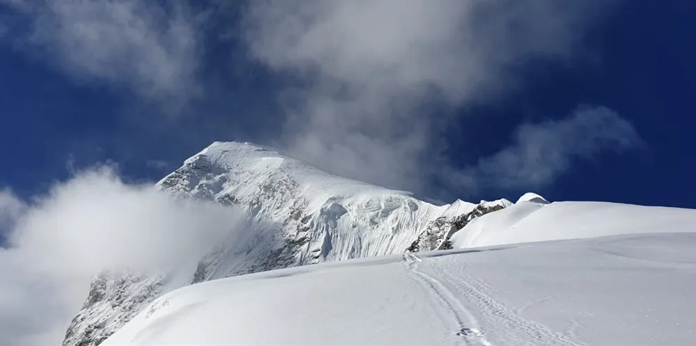
Standing at 7,075 m (23,212 ft), Satopanth Peak dominates the upper reaches of the Gangotri Glacier system and has long been respected as one of India's classic high-altitude mountaineering objectives. Frequently used as preparation for greater Himalayan expeditions, it demands exceptional endurance, technical climbing ability, and prolonged performance above 6,000 meters.
The expedition progresses across the vast Gangotri and Chaturangi glaciers before establishing multiple high camps beneath the mountain. Climbers negotiate crevasses, steep ice gullies, sustained snow slopes, and the exposed Northeast Ridge before reaching the summit, where panoramic views extend across Shivling, Meru, Chaukhamba, and the surrounding Garhwal giants.
Combining significant altitude with sustained technical climbing, Satopanth Peak remains one of India's premier training grounds for elite Himalayan alpinists.
Quick Facts
Duration
Max Altitude
Difficulty
Best Time
Trek Distance
Trail Atmosphere
Stargazing
Class 1 Dark Sky
Scent Profile
Silence Level
~10 dB
Vertigo Factor
7 / 10
Iconic Spots
Vasuki Tal Lake
Chaturangi Glacier Crossing
Razor-Edge Summit Ridge
Environment
Nature & Culture
Flora & Fauna
Flora
Fauna
The name Satopanth means "Path of Truth," and locals believe the holy trinity (Brahma, Vishnu, and Shiva) meditate at its lake.
— Local folklore
Spiritual & Cultural Significance
The local Hindu community associates these peaks with shrines and abodes of Shiva or local devtas.
🕐 Shrine Timings: N/A
Temple Protocols
- •No leather items inside shrines
- •Maintain silence and decorum near holy sites
Technical Details
Challenge & Preparation
Primarily a cardio demand and terrain ruggedness challenge
An elite-level undertaking with extreme cardio demand, terrain ruggedness, and altitude exposure. This route will push every dimension of your physical and mental endurance to the limit.
Personal Readiness
Am I ready?
Planning
Logistics & Trail Intel
Getting There
Route to Base
Drive from Dehradun/Rishikesh to Gangotri, start trek
Base Village
Gangotri
10,170 ft
Nearest Railhead
Dehradun / Rishikesh railway station
Nearest Airport
Jolly Grant Airport, Dehradun (DED)
Last ATM
Gangotri
Nearest Medical Facility
District Hospital or AIIMS Rishikesh
Mobile Signal
None at base camp. Sporadic signal at Gangotri.
Water Sources
Glacial meltwater streams near base camp, snow melt required at high camp.
Charging
None after leaving the base village Gangotri. Solar chargers or power banks required.
For Drivers
Road Condition
Highways from Dehradun/Rishikesh up to Gangotri are highly landslide-prone during rain, double-lane mountain highway with ongoing widening.
Gangotri or nearest transit town
Trail Culinary & Diet
Don't miss the High altitude noodle soups and organic barley porridge.
Buy specialized diet items at Rishikesh / Dehradun
The Content & Remote Hub
No DronesStrictly banned or restricted due to proximity to military border posts.Top Vlog Spots
Video Calls
none
Est. 0 Mbps
UPI Reliability
1/10
Permits and Regulations
Peak booking must be registered with the Indian Mountaineering Foundation (IMF). Liaison officer may be assigned for peaks above 6,500m.
Learn more about how we vet operators and ensure transparency on our why MountRoutes page.
Packing List
Mountaineering Clothing
- Thermal baselayers
- Windproof shell jacket/trousers
- Down jacket comfort to -15C
Footwear & Traction
- Stiff-soled B2/B3 mountaineering boots
- Merino wool socks
- 12-point crampons
Climbing Gear
- Climbing harness
- Ascender (Jumar)
- Descending device (descender)
- Ice axe
- Climbing helmet
Deep Dives
Explore Further
Editor's Notes
Practice clipping and unclipping from fixed ropes on steep slopes until it is second nature. The crux section above 18200ft requires absolute confidence.
Explore In Detail
Day by Day Itinerary
22-day route reaching 23,212ft. Covers 80km of varied terrain.
→ See full itinerary with altitude profileDifficulty & Fitness
Rated extreme. Glacial travel with crevasses above 16000ft.
→ See difficulty breakdown and fitness guideCost & Pricing
Packages range from ₹1,95,000 – ₹2,80,000. Inclusions and hidden costs vary by operator tier.
→ See full cost breakdownFrequently Asked Questions
What is the overall climbing difficulty grade of Mt. Satopanth?
The climbing grade of Mt. Satopanth is classified as AD+. This means it involves technical glacier routes, steep snow/ice slopes up to 50 degrees, and exposed ridge traverses requiring rope team dynamics, jumar ascents, and rappelling.
Are there any mandatory physical or trekking prerequisites for the Mt. Satopanth expedition?
Yes. Because Mt. Satopanth rises above 7,000m (23212ft), you must have successfully summitted at least one technical 6,000m peak (like Stok Kangri, Kang Yatse, or Mentok) and be capable of carrying a 15kg load on steep moraine.
Is an IMF peak permit and Liaison Officer required for Mt. Satopanth?
Yes. All peaks in India require booking through the Indian Mountaineering Foundation (IMF). For Mt. Satopanth (7075m), a Liaison Officer (LO) is strictly mandated by the IMF to accompany the team, manage environmental logs, and coordinate search and rescue if needed.
What is the best season to attempt the Mt. Satopanth expedition?
There are two windows: Pre-monsoon (May to June) and Post-monsoon (September to October). Pre-monsoon has more consolidated snow bridging crevasses, while post-monsoon offers extremely clear weather but colder temperatures.
What is the technical crux of the standard route on Mt. Satopanth?
The standard route via Northeast Ridge Standard Route features its main crux at the infamous knife-edge ridge at ~6,500m, followed by the steep snow slopes leading to the summit.
What camp progression is established on the Mt. Satopanth expedition?
The progression starts at the base village Gangotri (10170ft). We set up Vasuki Tal Base Camp at 16000ft, followed by Camp 1 (Sundar Bamak) at 18200ft. A Summit Camp is also established higher up to shorten the final summit day climb.
What boots are mandatory for this expedition?
For Mt. Satopanth, B3 double mountaineering boots (e.g., La Sportiva Spantik or Scarpa Phantom 6000) are strictly mandatory. Double boots protect against frostbite in sub-zero temperatures (down to -25°C) and provide the necessary stiffness for vertical front-pointing on ice.
Where is the nearest medical emergency facility and evacuation route for Mt. Satopanth?
Evacuation is via Evacuate to Vasuki Tal Base Camp, manual carry across Chaturangi to Tapovan, vehicle to Uttarkashi Hospital.. The nearest hospital is located in Uttarkashi (District Hospital) or Joshimath (Army/Civil Hospital), which has facilities for treating acute mountain sickness (AMS) and traumatic injuries.
How do we source water during the expedition camps?
At Vasuki Tal Base Camp, water is sourced directly from glacial meltwater streams using filtration. At higher camps like Camp 1 (Sundar Bamak), all running water is frozen, requiring team members to collect clean snow and melt it using high-altitude multi-fuel stoves.
What is the acclimatization rotation schedule for this climb?
We follow the "climb high, sleep low" rule. Climbers will perform a load ferry from Vasuki Tal Base Camp to Camp 1 (Sundar Bamak), caching gear, and return to sleep at the lower camp. This triggers red blood cell production before moving up permanently.
Is satellite communication available during the expedition?
Satellite phones (like Thuraya or Iridium) are restricted in India. However, the expedition leader carries an authorized satellite communicator (like Garmin inReach) for weather reports and emergency SOS signals, registered with local authorities.
Where is the last ATM and cellular network location?
The last ATM and cellular connectivity is at Gangotri or the nearest highway town. Once we trek past the road head, there is zero mobile signal, and satellite/VHF radios are the only forms of communication.
What is the local cultural significance of Mt. Satopanth?
The name Satopanth means "Path of Truth," and locals believe the holy trinity (Brahma, Vishnu, and Shiva) meditate at its lake.
What is the estimated success rate for summits on Mt. Satopanth?
The average success rate is approximately 55%. Success depends heavily on weather windows, team physical preparation, and individual acclimatization.
What high-altitude emergency medicines are carried?
The medical kit contains Diamox (acetazolamide) for AMS, Dexamethasone for HACE (High Altitude Cerebral Edema), and Nifedipine for HAPE (High Altitude Pulmonary Edema). Oxygen cylinders are kept at Base Camp and High Camp for emergencies.
Still deciding?
Compare routes side-by-side to find the perfect match for your fitness, dates, and budget.
Everything you need to know, in one place. Someone else in your group needs to see this.
Planning Satopanth Peak Expedition?
Get route conditions, operator updates, and season windows before booking.
Don't miss out! Follow us for route updates@mountroutes|LinkedIn
No spam. Only useful trek updates.
Ready to walk this route?
You’ve read the guide, now find the perfect local team to take you there. Compare our verified list of operators.
Compare verified operators