
Explore
Intelligence
Essential Planning Guide
Marahni Ridge Trek — Complete Guide (2026)
Vibe & Scenery
The Experience
Introduction
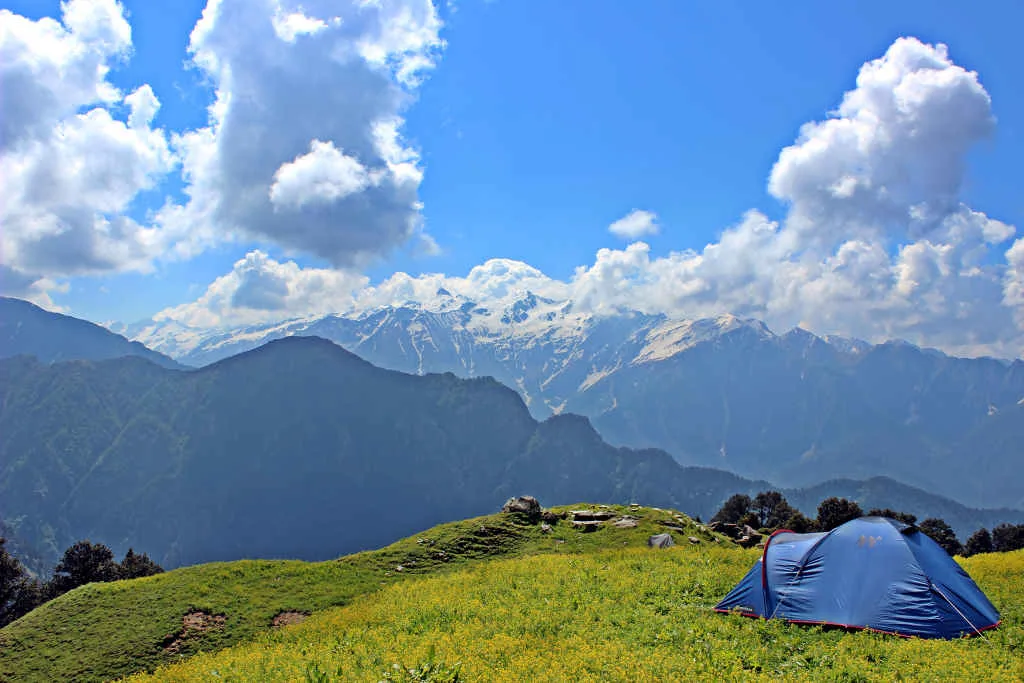
The Marahni Ridge Trek ascends from the Banjar region onto a broad Himalayan ridgeline separating the Banjar and Tirthan valleys. Walking along the ridge provides continuous views across forested valleys, terraced villages, and the surrounding mountain ranges of the western Himalayas.
Characterized by open grasslands and gentle ridge walking, the route is popular for sunrise and sunset views while remaining relatively quiet compared to more established trekking destinations nearby. The ridge also serves as seasonal grazing ground for local communities.
Suitable for trekkers seeking panoramic scenery without major altitude or technical challenges, Marahni Ridge is an excellent offbeat trek in the Banjar–Tirthan region.
Quick Facts
Duration
Max Altitude
Difficulty
Best Time
Trek Distance
Trail Atmosphere
Stargazing
Class 2 Dark Sky
Scent Profile
Silence Level
~25 dB
Vertigo Factor
2 / 10
Iconic Spots
Marahni Ridge Sunset
Environment
Nature & Culture
Flora & Fauna
Flora
Fauna
The Marahni ridge is locally called 'the dividing back' — believed in Pahari tradition to be the body of a mountain giant who turned to stone separating two warring village valleys in ancient times.
— Local folklore
Spiritual & Cultural Significance
A traditional pastoral route in the Kullu hills.
🕐 Shrine Timings: N/A
Temple Protocols
Technical Details
Challenge & Preparation
Primarily a joint & muscle impact and cardio demand challenge
A capable trekker's route dominated by extreme joint & muscle impact.
Personal Readiness
Am I ready?
Planning
Logistics & Trail Intel
Getting There
Route to Base
Banjar is well-connected by HRTC bus from Kullu (3 hrs), Manali (5 hrs), and Delhi (12 hrs via Aut)
ATMs and all services available
Base Village
Banjar Town, Kullu District
5,200 ft
Nearest Railhead
Rishikesh Railway Station
Nearest Airport
Jolly Grant Airport, Dehradun
Last ATM
Banjar Town
Nearest Medical Facility
Banjar CHC
Mobile Signal
Intermittent signal on the ridge.
Water Sources
Village springs on approach. Seasonal stream on lower ridge. No water on crest — carry 2.5L.
Charging
Banjar town only.
For Drivers
Road Condition
Trek starts from Banjar town itself — no additional driving needed.
Banjar Town
Trail Culinary & Diet
Don't miss the Sidu (Kullu-style stuffed bread) from Banjar dhabas pre-trek
Buy specialized diet items at Banjar town (good variety of dhabas and guesthouses)
The Content & Remote Hub
Video Calls
none
Est. 5 Mbps
UPI Reliability
2/10
Permits and Regulations
No permits required. Open pastoral land. No GHNP boundary crossing.
Learn more about how we vet operators and ensure transparency on our why MountRoutes page.
Packing List
Ridge Walk Essentials
- Wind jacket — the Marahni ridge is consistently windy as a valley-divide ridge
- Trekking poles for the steep forest exit section
- Sunscreen and glacier glasses for the UV-exposed open ridge
Photography Priority
- Wide angle lens for the valley panorama
- Telephoto for identifying specific GHNP peaks from the ridge
- Tripod for sunset/sunrise shooting from the camp
Deep Dives
Explore Further
Editor's Notes
The approach from Banjar town passes through extensive apple orchards that cascade down the valley sides in May-June with blossom. Walking through this agricultural landscape — with Himalayan peaks behind and the smell of apple blossoms — is a uniquely Kullu experience.
Explore In Detail
Day by Day Itinerary
3-day route reaching 12,200ft. Covers 22km of varied terrain.
→ See full itinerary with altitude profileDifficulty & Fitness
Rated moderate. A spectacular ridge walk that offers deep drops on either side and dense forest approaches.
→ See difficulty breakdown and fitness guideCost & Pricing
Packages range from ₹7,000 - ₹12,000. Inclusions and hidden costs vary by operator tier.
→ See full cost breakdownFrequently Asked Questions
How difficult is the Marahni Ridge Trek?
It is classified as a easy trek. It takes 3 days and reaches a maximum altitude of 12200 ft. Trekkers should have steady cardiovascular endurance.
What is the risk of Acute Mountain Sickness (AMS) on the Marahni Ridge Trek?
Since the trail climbs up to 12200 ft, there is a distinct risk of AMS. Proper hydration, progressive pacing, and gradual acclimatization are highly advised.
Will I get mobile network or internet connectivity during Marahni Ridge Trek?
Connectivity is highly sporadic. The last reliable mobile signal is at Banjar. Limited signal at lower ridge. Zero at crest.. Expect complete digital isolation on the trail.
Where is the last reliable ATM before starting the Marahni Ridge Trek?
The last active ATM is located at Banjar Town. It is strongly recommended to withdraw sufficient cash at major transit hubs before starting.
Is the drinking water safe on the Marahni Ridge Trek trail?
Fresh stream water is abundant, but water treatment is mandatory. Carry 2.5L from last village spring. No water on ridge crest.
Can I rent trekking gear at Banjar Town, Kullu District?
Rental options at Banjar Town, Kullu District are extremely limited. It is best to rent or purchase all essential gear in major hubs before reaching the base.
What permits are required for the Marahni Ridge Trek?
No permits required. Open pastoral land. No GHNP boundary crossing.
What is the emergency evacuation protocol on the Marahni Ridge Trek?
Return to Banjar is close — 4-5 hours from ridge. Banjar has road access and CHC. In case of extreme emergencies, helicopter evacuation can be coordinated if weather allows.
Where is the nearest specialized ICU or hospital for Marahni Ridge Trek?
The nearest specialized ICU is Kullu (60 km). For minor injuries, the nearest primary health center is located at Banjar CHC.
Is it safe to do the Marahni Ridge Trek as a solo female or solo traveler?
Manageable for experienced trekkers with offline GPS. A local Banjar guide adds significant value for route finding. The local communities are exceptionally welcoming and hospitable, but having a guide is highly recommended.
Are foreign nationals allowed to do the Marahni Ridge Trek?
Yes, foreign nationals are fully permitted with standard tourist permits and passport logging at regional checkpoints.
What kind of food is served during the Marahni Ridge Trek?
We serve highly nutritious, warm vegetarian meals suitable for high altitudes. You will also get to taste Sidu (Kullu-style stuffed bread) from Banjar dhabas pre-trek on the trail.
Are digital UPI/online payments accepted at the base village of Banjar Town, Kullu District?
While some local shops accept UPI at Banjar Town, Kullu District, connection is highly unreliable due to network dropouts. Make sure to carry physical cash.
What is the local cultural significance or folklore associated with Marahni Ridge Trek?
The Marahni ridge is locally called 'the dividing back' — believed in Pahari tradition to be the body of a mountain giant who turned to stone separating two warring village valleys in ancient times.
Still deciding?
Compare routes side-by-side to find the perfect match for your fitness, dates, and budget.
Everything you need to know, in one place. Someone else in your group needs to see this.
Planning Marahni Ridge Trek?
Get route conditions, operator updates, and season windows before booking.
Don't miss out! Follow us for route updates@mountroutes|LinkedIn
No spam. Only useful trek updates.
Ready to walk this route?
You’ve read the guide, now find the perfect local team to take you there. Compare our verified list of operators.
Compare verified operators