We are currently vetting local partners for Marahni Ridge Trek to ensure the highest safety standards. Be the first to know when it's open for booking.
Are you a local operator?
Join our platform to list your verified packages for Marahni Ridge Trek and reach thousands of trekkers directly.
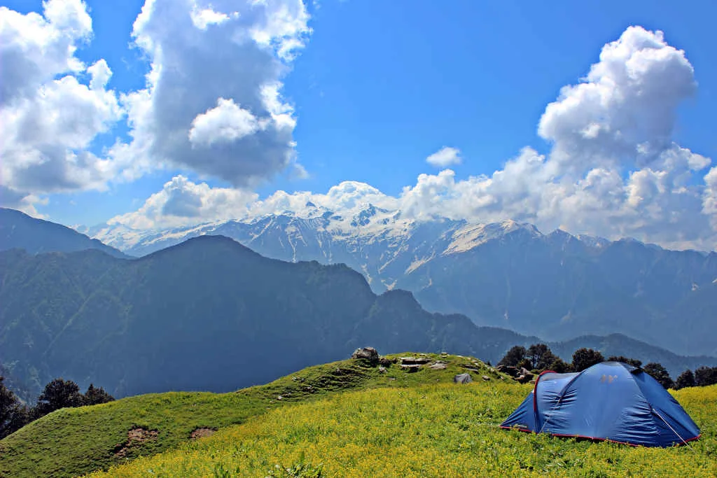
The Marahni Ridge Trek follows the high watershed between the Tirthan and Sainj valleys in the Great Himalayan National Park to an exposed ridgeline at 12,200 ft that divides two of Himachal's most pristine river ecosystems. This 4-day moderate-hard trek is a genuine wilderness ridge walk with forest and meadow terrain, extraordinary birding opportunities, and views across two vast UNESCO World Heritage landscape valleys. The Sainj Valley side reveals an entirely different ecological character — drier, higher, and more dramatic.
Trek Highlights
Marahni Ridge Sunset
The Banjar valley turning amber gold at sunset while the GHNP peaks behind catch the last high light — a two-world color show from a single ridge vantage point.
It is classified as a easy trek. It takes 3 days and reaches a maximum altitude of 12200 ft. Trekkers should have steady cardiovascular endurance.
What is the risk of Acute Mountain Sickness (AMS) on the Marahni Ridge Trek?
Since the trail climbs up to 12200 ft, there is a distinct risk of AMS. Proper hydration, progressive pacing, and gradual acclimatization are highly advised.
When is the absolute best time to do Marahni Ridge Trek?
May-June and September-November. October-November for the finest views and autumn color. Avoid monsoon months for obvious cloud cover.
Will I get mobile network or internet connectivity during Marahni Ridge Trek?
Connectivity is highly sporadic. The last reliable mobile signal is at Banjar. Limited signal at lower ridge. Zero at crest.. Expect complete digital isolation on the trail.
Where is the last reliable ATM before starting the Marahni Ridge Trek?
The last active ATM is located at Banjar Town. It is strongly recommended to withdraw sufficient cash at major transit hubs before starting.
Is the drinking water safe on the Marahni Ridge Trek trail?
Fresh stream water is abundant, but water treatment is mandatory. Carry 2.5L from last village spring. No water on ridge crest.
Can I rent trekking gear at Banjar Town, Kullu District?
Rental options at Banjar Town, Kullu District are extremely limited. It is best to rent or purchase all essential gear in major hubs before reaching the base.
What permits are required for the Marahni Ridge Trek?
No permits required. Open pastoral land. No GHNP boundary crossing.
What is the emergency evacuation protocol on the Marahni Ridge Trek?
Return to Banjar is close — 4-5 hours from ridge. Banjar has road access and CHC. In case of extreme emergencies, helicopter evacuation can be coordinated if weather allows.
Where is the nearest specialized ICU or hospital for Marahni Ridge Trek?
The nearest specialized ICU is Kullu (60 km). For minor injuries, the nearest primary health center is located at Banjar CHC.
Is it safe to do the Marahni Ridge Trek as a solo female or solo traveler?
Manageable for experienced trekkers with offline GPS. A local Banjar guide adds significant value for route finding. The local communities are exceptionally welcoming and hospitable, but having a guide is highly recommended.
Are foreign nationals allowed to do the Marahni Ridge Trek?
Yes, foreign nationals are fully permitted with standard tourist permits and passport logging at regional checkpoints.
What kind of food is served during the Marahni Ridge Trek?
We serve highly nutritious, warm vegetarian meals suitable for high altitudes. You will also get to taste Sidu (Kullu-style stuffed bread) from Banjar dhabas pre-trek on the trail.
Are digital UPI/online payments accepted at the base village of Banjar Town, Kullu District?
While some local shops accept UPI at Banjar Town, Kullu District, connection is highly unreliable due to network dropouts. Make sure to carry physical cash.
What is the local cultural significance or folklore associated with Marahni Ridge Trek?
The Marahni ridge is locally called 'the dividing back' — believed in Pahari tradition to be the body of a mountain giant who turned to stone separating two warring village valleys in ancient times.
How difficult is the Marahni Ridge Trek?
It is classified as a easy trek. It takes 3 days and reaches a maximum altitude of 12200 ft. Trekkers should have steady cardiovascular endurance.
What is the risk of Acute Mountain Sickness (AMS) on the Marahni Ridge Trek?
Since the trail climbs up to 12200 ft, there is a distinct risk of AMS. Proper hydration, progressive pacing, and gradual acclimatization are highly advised.
When is the absolute best time to do Marahni Ridge Trek?
May-June and September-November. October-November for the finest views and autumn color. Avoid monsoon months for obvious cloud cover.
Will I get mobile network or internet connectivity during Marahni Ridge Trek?
Connectivity is highly sporadic. The last reliable mobile signal is at Banjar. Limited signal at lower ridge. Zero at crest.. Expect complete digital isolation on the trail.
Where is the last reliable ATM before starting the Marahni Ridge Trek?
The last active ATM is located at Banjar Town. It is strongly recommended to withdraw sufficient cash at major transit hubs before starting.
Is the drinking water safe on the Marahni Ridge Trek trail?
Fresh stream water is abundant, but water treatment is mandatory. Carry 2.5L from last village spring. No water on ridge crest.
Can I rent trekking gear at Banjar Town, Kullu District?
Rental options at Banjar Town, Kullu District are extremely limited. It is best to rent or purchase all essential gear in major hubs before reaching the base.
What permits are required for the Marahni Ridge Trek?
No permits required. Open pastoral land. No GHNP boundary crossing.
What is the emergency evacuation protocol on the Marahni Ridge Trek?
Return to Banjar is close — 4-5 hours from ridge. Banjar has road access and CHC. In case of extreme emergencies, helicopter evacuation can be coordinated if weather allows.
Where is the nearest specialized ICU or hospital for Marahni Ridge Trek?
The nearest specialized ICU is Kullu (60 km). For minor injuries, the nearest primary health center is located at Banjar CHC.
Is it safe to do the Marahni Ridge Trek as a solo female or solo traveler?
Manageable for experienced trekkers with offline GPS. A local Banjar guide adds significant value for route finding. The local communities are exceptionally welcoming and hospitable, but having a guide is highly recommended.
Are foreign nationals allowed to do the Marahni Ridge Trek?
Yes, foreign nationals are fully permitted with standard tourist permits and passport logging at regional checkpoints.
What kind of food is served during the Marahni Ridge Trek?
We serve highly nutritious, warm vegetarian meals suitable for high altitudes. You will also get to taste Sidu (Kullu-style stuffed bread) from Banjar dhabas pre-trek on the trail.
Are digital UPI/online payments accepted at the base village of Banjar Town, Kullu District?
While some local shops accept UPI at Banjar Town, Kullu District, connection is highly unreliable due to network dropouts. Make sure to carry physical cash.
What is the local cultural significance or folklore associated with Marahni Ridge Trek?
The Marahni ridge is locally called 'the dividing back' — believed in Pahari tradition to be the body of a mountain giant who turned to stone separating two warring village valleys in ancient times.
Are you a local operator?
Join our platform to list your verified packages for this trek.