
Explore
Intelligence
Detailed Route
Lamayuru Chilling Trek Itinerary — Day by Day Route & Camps
A 5-day cultural journey starting from the 'moonland' of Lamayuru, crossing three high passes, sleeping in remote village homestays, and ending at the Zanskar river in Chilling.
Standard RouteThis is the standard mountain pacing for this trek. Specific operators may add an acclimatization day or alter the starting point. Check individual operator schedules for their exact logistics.
Duration
5 Days
Total Distance
58.0 KM
Max Altitude
16,240 FT
Trek Type
linear
Day by Day Breakdown
Camp Alt
10,500 ft
Day Gain
-1,000 ft
Lamayuru to Wanla via Prinkti La
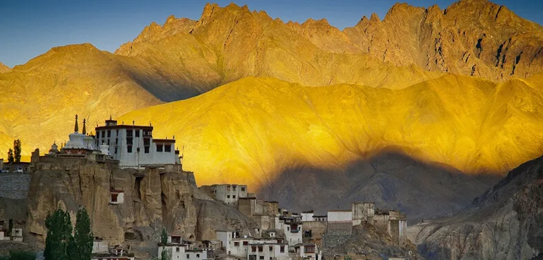
After visiting the ancient Lamayuru monastery, the trek begins with a short, steep climb to Prinkti La. From the pass, a narrow, spectacular descent through a tight gorge leads to the village of Shilla, followed by a short walk to the lush oasis of Wanla.
Key Landmarks
Staying At
Crossing the high-altitude pass bridges two distinct watershed systems, shifting the expedition over the glaciated divide and down into a new river basin.
Field Notes
Use Trekking Poles
Trekking poles are highly recommended to save your knees on the descent.
INFOSlower Progress
Progress will be significantly slower and more taxing on your ankles than trail distance suggests.
Camp Alt
12,200 ft
Day Gain
+1,700 ft
Wanla to Hinju
The trail follows the Yapola river along a dusty jeep track for a few kilometers until the village of Phenjilla. From here, the route splits into a beautiful side valley, steadily ascending past barley fields and traditional houses to reach the village of Hinju.
Key Landmarks
Staying At
Crossing the high-altitude pass bridges two distinct watershed systems, shifting the expedition over the glaciated divide and down into a new river basin.
Camp Alt
14,500 ft
Day Gain
+2,300 ft
Today's Objective
🏔 Cross Hinju To Sumda Doksa Via Kongskil La
The hardest day of the trek. The trail climbs steeply past the summer pastures of Hinju Doksa. The final push to Kongskil La (16,240 ft) is a grueling zigzag on loose scree. The reward is a panoramic view of the Stok and Karakoram ranges. The descent is incredibly steep and rocky.
Key Landmarks
Staying At
Crossing the high-altitude pass bridges two distinct watershed systems, shifting the expedition over the glaciated divide and down into a new river basin.
Field Notes
Use Trekking Poles
Trekking poles are highly recommended to save your knees on the descent.
INFOSlower Progress
Progress will be significantly slower and more taxing on your ankles than trail distance suggests.
Camp Alt
14,400 ft
Day Gain
-100 ft
Sumda Doksa to Dung Dung Chan La Base
A beautiful, undulating walk. After a few minor river crossings, you reach the picturesque village of Sumda Chenmo, famous for its traditional wood carvers. From the village, the trail begins a gradual climb toward the base of tomorrow's pass.
Key Landmarks
Staying At
The route follows the river valley. The path breaches the mountain barrier crossing the watershed.
Camp Alt
11,600 ft
Day Gain
-2,800 ft
Dung Dung Base to Chilling via Dung Dung Chan La
The day starts with a straightforward, steady climb to Dung Dung Chan La (15,800 ft). From the top, you get magnificent views of the Zanskar valley and the Stok Kangri peak. The descent to Chilling is long, steep, and barren. The trek ends at the roadhead in Chilling.
Key Landmarks
Crossing the high-altitude pass bridges two distinct watershed systems, shifting the expedition over the glaciated divide and down into a new river basin.
Field Notes
Use Trekking Poles
Trekking poles are highly recommended to save your knees on the descent.
INFOSlower Progress
Progress will be significantly slower and more taxing on your ankles than trail distance suggests.
Trek Extensions & Add-ons
Markha Valley Traverse
+6 DaysUpon reaching Chilling, cross the Zanskar river via the ropeway/bridge and immediately begin the famous Markha Valley trek, ending at Hemis.
Plan Your Trek:
Ready to book? Compare verified operators for Lamayuru Chilling Trek — transparent pricing, no paid rankings.
Still deciding?
Compare routes side-by-side to find the perfect match for your fitness, dates, and budget.
Day by day, camp by camp. Send this to your group so everyone's on the same page.
Step 4: Cost & Logistics
You understand the route.
Now see what services, permits, and logistics actually cost.
View Cost Breakdown