
Explore
Intelligence
Essential Planning Guide
Lamayuru Chilling Trek — Complete Guide (2026)
Vibe & Scenery
The Experience
Introduction
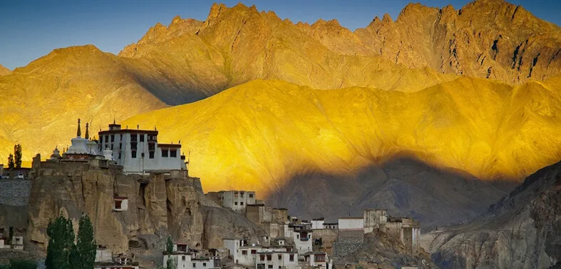
The Lamayuru–Chilling Trek is among Ladakh's classic trekking routes, combining spectacular mountain scenery with rich Buddhist culture. Starting beneath the famous Lamayuru Monastery, the trail crosses three mountain passes while connecting traditional villages that remain active throughout the short Himalayan summer.
Unlike Ladakh's longer expedition routes, this trek remains below 5,000 metres for most of its duration, making it more accessible to trekkers who have acclimatized in Leh. Along the way, travellers experience remote monasteries, barley fields, narrow gorges, and welcoming homestays that offer insight into everyday Ladakhi life.
Moderate difficulty, cultural immersion, and varied landscapes make Lamayuru–Chilling one of the region's most rewarding introductory treks.
Quick Facts
Duration
Max Altitude
Difficulty
Best Time
Trek Distance
Trail Atmosphere
Stargazing
Class 2 Dark Sky
Scent Profile
Silence Level
~25 dB
Vertigo Factor
3 / 10
Iconic Spots
Lamayuru Moonland
Kongskil La Viewpoint
Sumda Chenmo Village
Environment
Nature & Culture
Flora & Fauna
Flora
Fauna
Legend has it that Lamayuru was once a massive lake. The great mystic Naropa mediated in a cave here (still visible) and caused the lake to drain away, allowing the monastery to be built.
— Local folklore
Spiritual & Cultural Significance
Lamayuru (Yungdrung Gompa) is one of the oldest and largest monasteries in Ladakh, deeply tied to the mystic Naropa.
🕐 Shrine Timings: Daylight hours
Temple Protocols
- •Remove shoes before entering.
- •Walk clockwise around chortens.
Festivals & Dates
Technical Details
Challenge & Preparation
Primarily a cardio demand and altitude exposure challenge
A demanding expedition dominated by extreme cardio demand.
Personal Readiness
Am I ready?
Planning
Logistics & Trail Intel
Getting There
Route to Base
Fly to Leh
Spend 2 days acclimatizing
Hire a taxi or take a local bus from Leh to Lamayuru via the Srinagar-Leh highway (approx
115 km, 3-4 hours)
Base Village
Lamayuru
11,500 ft
Last ATM
Leh / Khaltse (near Lamayuru)
Nearest Medical Facility
Khaltse PHC (Start). Sonam Norboo Memorial Hospital in Leh (End).
Mobile Signal
Total blackout on the trail.
Water Sources
Springs and streams in the villages. Always filter or boil water provided at homestays.
Charging
Available at most village homestays (Wanla, Hinju), usually powered by solar or evening generators.
For Drivers
Road Condition
The highway from Leh to Lamayuru is fully paved, smooth, and incredibly scenic.
Khaltse
Trail Culinary & Diet
Don't miss the Momos and Skyu (local pasta)
Buy specialized diet items at Leh
The Content & Remote Hub
Top Vlog Spots
Video Calls
none
Est. 0 Mbps
UPI Reliability
1/10
Permits and Regulations
No special Protected Area Permit (PAP) is required for Indian or Foreign nationals for this specific route. Standard passport/ID checks apply at military checkpoints on the highway to Lamayuru.
Learn more about how we vet operators and ensure transparency on our why MountRoutes page.
Packing List
Core Clothing Layers
- Lightweight, breathable full-sleeve t-shirts (for intense sun protection)
- Trekking pants (lightweight and quick-drying)
- Fleece jacket (for chilly evenings)
- Lightweight down jacket (temperatures drop rapidly after sunset)
- Windproof shell jacket
Footwear & Protection
- Sturdy, mid-ankle trekking boots (well broken-in)
- Merino wool trekking socks (x3 pairs)
- Camp sandals (for evening rest)
- Basic gaiters (optional, only if trekking in early June)
Head & Hands
- Wide-brimmed sun hat or desert cap with neck flap (MANDATORY)
- Category 3 or 4 polarized sunglasses
- Fleece beanie for the night
- Light windproof gloves
Gear & Accessories
- 30-40 litre daypack with rain cover
- Trekking poles (essential for scree descents off the passes)
- Hydration bladder or 2L water bottles
- High SPF (50+) sunscreen and lip balm
- Personal first aid kit with Diamox
- Headlamp with spare batteries
Deep Dives
Explore Further
Editor's Notes
Explore In Detail
Day by Day Itinerary
5-day route reaching 16,240ft. Covers 58.0km of varied terrain.
→ See full itinerary with altitude profileDifficulty & Fitness
Rated challenging. The trail oscillates between well-trodden village paths and raw, loose scree on the mountain passes. The deep gorges can magnify the midday heat.
→ See difficulty breakdown and fitness guideCost & Pricing
Packages range from 15,000 - 25,000 INR. Inclusions and hidden costs vary by operator tier.
→ See full cost breakdownFrequently Asked Questions
Is this trek suitable for beginners?
It is suitable for fit beginners who have fully acclimatized. While technically a 'Moderate' trek, it crosses a 16,240 ft pass (Kongskil La). You must spend at least 2-3 days in Leh before starting.
What is the terrain like?
The terrain is incredibly diverse. You start in the barren, eroded 'moonscape' of Lamayuru, cross rocky scree-filled passes, and descend into surprisingly lush, green valleys cultivated by remote villages.
Are there homestays available?
Yes. This route passes through the villages of Wanla, Hinju, and Sumda Chenmo, making it possible to do this as a 'tea-house' or homestay trek, significantly reducing the gear you need to carry.
How difficult are the mountain passes?
There are three passes: Prinkti La (12,300 ft), Kongskil La (16,240 ft), and Dung Dung Chan La (15,800 ft). They are steep and physically demanding, and the descents often feature loose scree, but they are not technical and require no mountaineering gear.
Is there phone connectivity?
Expect zero mobile connectivity once you leave Lamayuru until you reach the roadhead at Chilling.
How do I reach the start point?
Lamayuru is located on the main Leh-Srinagar highway. It is a very scenic 3-4 hour drive (approx. 115 km) from Leh.
What is the best time to do this trek?
The ideal window is from mid-June to late September. The region is in a rain shadow, so July and August offer clear, sunny (though hot) weather.
Can I combine this trek with others?
Yes. Upon reaching Chilling, many trekkers cross the Zanskar river and continue into the Markha Valley trek, making it a massive 12-day traverse.
Still deciding?
Compare routes side-by-side to find the perfect match for your fitness, dates, and budget.
Everything you need to know, in one place. Someone else in your group needs to see this.
Planning Lamayuru Chilling Trek?
Get route conditions, operator updates, and season windows before booking.
Don't miss out! Follow us for route updates@mountroutes|LinkedIn
No spam. Only useful trek updates.
Ready to walk this route?
You’ve read the guide, now find the perfect local team to take you there. Compare our verified list of operators.
Compare verified operators