Explore
Intelligence
Detailed Route
Bhrigu Lake Trek Itinerary — Day by Day Route & Camps
Bhrigu Lake Trek is a 4-day loop from Manali, with the sacred alpine lake frozen at 14,100ft reached on Day 3.
Standard RouteThis is the standard mountain pacing for this trek. Specific operators may add an acclimatization day or alter the starting point. Check individual operator schedules for their exact logistics.
Duration
4 Days
Total Distance
22 KM
Max Altitude
14,100 FT
Trek Type
linear
Day by Day Breakdown
Camp Alt
12,200 ft
Day Gain
+5,500 ft
Drive to Gulaba & Trek to Rola Kholi
First camp in tents. The meadow offers an unobstructed view of the Dhauladhar range to the north and the Pir Panjal to the south. Technical: The drive from Manali to Gulaba takes 45 mins on the old Rohtang road. Trek begins immediately with a steep ascent through birch and rhododendron forests. The last 1 km to Rola Kholi is a false-flat meadow that feels endless when tired. Trekking poles essential from the start. Landscape: Rola Kholi means 'the shepherd's shelter'. These high-altitude meadows have been summer grazing grounds for Gaddi shepherds from Kangra for centuries. Their nomadic culture is inseparable from these mountains. Safety: Rapid altitude gain today (8.5k to 11k). Monitor for headaches. Hydrate aggressively — minimum 3L. Acclimatize by walking around the meadow before settling into tents.
Key Landmarks
Staying At
The vehicle route ends, transitioning into a forested ascent toward the Rola Kholi meadow.
Camp Alt
12,200 ft
Day Gain
0 ft
Today's Objective
🏔 Cross Bhrigu Lake
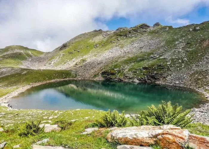
Return to Rola Kholi or descend to Pandu Ropa (lower camp) depending on weather. This is the defining day of the trek. Technical: This is the crux day. You gain 3,100 ft in a single push. The trail is steep, unmarked in sections, and involves scrambling over loose moraine rocks in the final 500 ft. In June, the last ridge is snow-covered and requires microspikes. The lake itself sits in a glacial cirque — the wind can be brutal. Spend no more than 45 minutes at the lake if weather is turning. Landscape: Legend says Rishi Bhrigu wrote the 'Bhrigu Samhita' (an astrological scripture predicting every human's destiny) while meditating here. Locals believe the lake water has healing properties. In winter, the frozen lake surface turns a surreal shade of pale green. Safety: AMS Risk Zone: 14,100 ft is serious altitude. Mandatory oximeter check before the final push. Turnback time is 1:00 PM — after that, cloud build-up makes the descent treacherous. Do NOT attempt to camp at the lake; there is no flat ground and wind speeds can exceed 50 kmph.
Key Landmarks
Staying At
The Rola Kholi meadow broadens into a barren rocky approach to the Bhrigu Lake basin.
Field Notes
Use Trekking Poles
Trekking poles are highly recommended to save your knees on the descent.
INFOSlower Progress
Progress will be significantly slower and more taxing on your ankles than trail distance suggests.
Camp Alt
6,700 ft
Day Gain
-5,500 ft
Trek to Gulaba & Drive to Manali
Reach Manali by 3 PM. Hot springs at Vashisht temple nearby for post-trek recovery. Technical: Fast descent. Hard on the knees. Use Z-walking technique on the steepest sections. The trail can be muddy and slippery in monsoon. Reach Gulaba by noon for the drive back. Landscape: The descent offers a completely different perspective — you can see the entire Kullu Valley spread below you, with the Beas river glinting like a silver thread. Safety: Knee Strain Alert. Descending 4,300 ft in one shot is demanding. Take breaks every 30 minutes. Stretch hamstrings and quads.
Key Landmarks
The Rola Kholi meadow transitions steeply downward through the forest back to the Gulaba roadhead.
Field Notes
KEY ACTIONRiver Crossings
Plan to cross early in the day before snowmelt swells the water levels. Unclip backpack waist belts before crossing.
Trek Extensions & Add-ons
Pandu Ropa Meadow
+1 DayShort detour to a massive meadow known for its distinct terraced landscape.
Plan Your Trek:
Ready to book? Compare verified operators for Bhrigu Lake Trek — transparent pricing, no paid rankings.
Still deciding?
Compare routes side-by-side to find the perfect match for your fitness, dates, and budget.
Day by day, camp by camp. Send this to your group so everyone's on the same page.
Step 4: Cost & Logistics
You understand the route.
Now see what services, permits, and logistics actually cost.
View Cost Breakdown