Kalindikhal is one of the most dangerous, thrilling and long treks which connects Gangotri to Badrinath via a high altitude pass called Kalindi Khal. I got this opportunity in 2018 when I was exploring famous treks in Uttarakhand.
September 4, 2018
I got ready from Vikasnagar early morning and reached Dehradun from where I got picked up by the other trekkers coming from Haridwar. They picked me up from Dehradun and we headed towards Uttarkashi. I met Jung Bahadur who would be my tent-mate for the whole journey. He was like me — working in an IT company. We reached Uttarkashi, took a short rest and then headed towards Gangotri. Manoj Rawat had arranged very good accommodation for us there.
September 5, 2018
Next day we headed to Bhojbasa — a good 18 km from Gangotri. Me and Jung went to see the famous Surya Kund after darshan at Gangotri Temple. After breakfast we got briefed about the day's journey.
This was my first time in Gangotri National Park. I made my first mistake here — I chose to walk in sandals. I was also suffering from back pain before the trek. By the time we reached Bhojbasa, my back was hurting and my knees were shot. First day. Issues already started. On the hardest trek in Uttarakhand.
Before Bhojbasa there is a place called Chirbasa — jungle of pines. Weather was good. Cold wind but manageable. We reached Bhojbasa in the evening. Porters had pitched the tents. We had a big dinner and got to know the fellow trekkers.
Note this: after Chirbasa there is no mobile signal. For the next two weeks we were completely off the grid. Bhojbasa altitude: 3775m.
September 6, 2018
We woke up early and saw people crossing the river Bhagirathi via a pulley bridge system towards Tapovan. We had breakfast, packed lunch, and departed from Bhojbasa around 9 AM.
By 11 or 12 we reached Gaumukh. From there it was full glacier and moraine. It is a vast glacier — full of boulders and crevasses. We reached Nandanvan by 4-5 PM. I felt exhausted for the first time.
I asked our trek leader to pitch our tent so that we could see Shivling and Kedar Dome from inside — first thing in the morning when we opened the tent.
September 7, 2018
This is the start of many days of suffering. Target was Vasuki Tal — different from the Vasuki Tal near Kedarnath. I decided to hand my bag to the porters. AMS had started.
“At 5,048m, Vasuki Tal is the first major altitude threshold. Check your risk profile for symptoms and prevention before you push higher.”
I was moving slowly. The whole day we walked on moraine. Barren land — not a single blade of grass or tree. We reached near Vasuki Tal. A few tents from the Indian Navy were already there — base camp for Satopanth Peak.
September 8, 2018
This was supposed to be the acclimatisation day. Instead of walking around to help with acclimatisation, I slept all day. This was my second big mistake. Sleeping increases AMS. I knew this and did it anyway. The AMS got significantly worse.
September 9, 2018
Campsite: Khara Patthar. We were well above 5000m now. The path was marked surprisingly well for such a remote route. We were in the valley of glaciers — a supporting glacier of the Gangotri Glacier. Nights were cold and very dark.
September 10, 2018
Moving towards Shweta Glacier and the Kalindi Khal side now. I don't remember much from this day because of heavy tiredness. Jung was walking alongside me the whole time, pushing me to keep going. We were walking above glaciers covered by boulders and mud. The path was constantly up and down.
September 11, 2018
Target: Kalindi Khal base camp. I was completely exhausted. Struggling to walk even a few steps. Jung was with me the whole time.
In the evening I was the last person on the trail. I saw the camp in the distance and then my feet simply stopped. I sat on a stone. I could not move. A few porters from our group came back and called out to me. One of them put me on his shoulders and carried me to camp.
“Kalindikhal is one of the toughest Himalayan passes. A physical readiness audit helps you understand if you're prepared for the relentless 6,000m demands.”
Upon reaching camp, Manjunath suggested to the trek leader that I should be sent back to Uttarkashi. I convinced them to let me continue. I was feeling extremely drowsy — a serious AMS symptom I did not fully understand at the time.
We all slept in one big tent that night. This night we slept over the glacier. We could feel water flowing beneath us.
September 12, 2018
We got up early. In my 28 years of life I had never seen sunlight appear so close — not from behind mountains, but right there at 4:20 AM.
We started moving slowly towards Kalindi Pass. Barely 1-2 km away. But to this day it feels like 10 km in my memory.
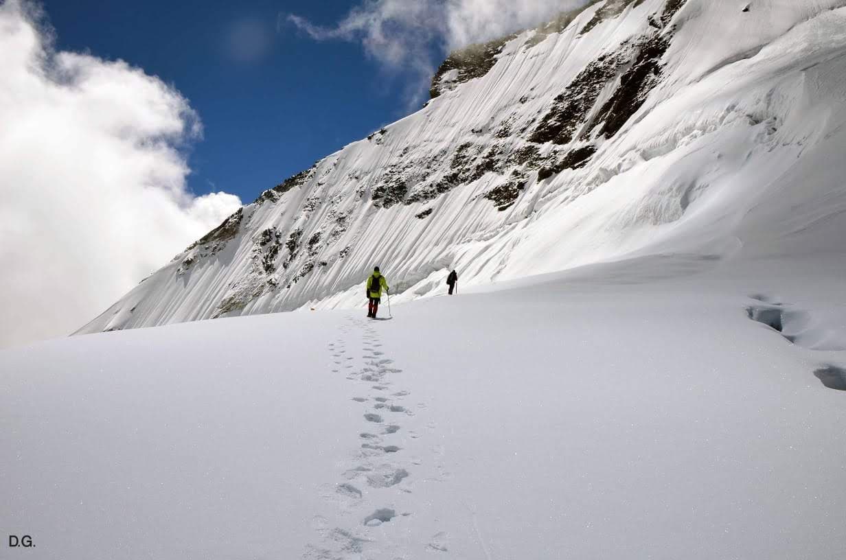
I was walking alone, far behind the others. I was afraid of the ice — afraid of crevasses. We were not carrying ropes or anchored to anything. Just walking uphill on ice, in the deepest part of the Himalayas. Tibet's barren plateau was on the other side.
I reached the pass at around 9:30 AM. 6000 metres. Our guides and porters did a small puja and offered gratitude to the mountains.
The descent started with a sharp drop. Porters had set up a small anchor and belay — we descended about 8-9 metres down a rock face. From there it was a vast snow field going downhill. Km after km of snow. I followed footprints. My shoes were completely soaked.
“Waterproof gear and the right layers are non-negotiable for glacier crossings. Cross-check your high-altitude essentials.”
I reached the campsite in the late evening. A small celebration. One of the days I will remember my whole life.
September 13, 2018
Closer to Badrinath now. A vast valley with multiple streams — we had to remove our shoes and wade through ice-cold water. We were told there had been a lake here that was swept away in the 2013 floods.
That evening snowfall started. We slept making plans to wake up early and reach Ghastoli in time to make Badrinath the same day.
September 14, 2018
We woke up to a heavy sound of landslides from the opposite mountains — caused by the night's snow and rain. We started our descent. Gorges and valleys narrowed. Vegetation slowly returned.
Near Ghastoli there was a spring — the most beautiful natural water body I have seen. We waited for the group, then with help from ITBP we were on a truck headed to Badrinath.
After darshan at the temple we headed to Joshimath. The long-awaited dream of crossing Kalindikhal was complete. That night in Joshimath we danced and thanked our porters and guide. Then we went home.